


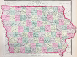
Frank A. Gray. "Gray's New Map of Iowa."
Philadelphia: O.W. Gray & Son, 1876. 11 3/4 x 16. Lithograph. Original hand color. Very good condition.
From one of their many atlases, this nicely detailed map of Iowa showing counties, towns, canals, roads, railroads and topography was made by the Philadelphia firm of O.W. Gray and Son. The firm began its publishing around mid-century and published regional and U.S. atlases up to the 1880s. This map is typical of their work, and its attractive presentation and interesting detail make it a nice example of late nineteenth century Philadelphia cartography.
 %20%0A%20%0Ahttps://philaprintshop.com/products/gray-frank-a-grays-new-map-of-iowa %20%0A%20%0AGray,%20Frank%20A.%20%22Gray's%20New%20Map%20of%20Iowa%22 %20%0A%20%0A//philaprintshop.com/cdn/shop/files/grayia1876thmb_1024x1024.jpg?v=1707331501 %20%0A%20%0AAntique Prints, Maps, Drawings, Paintings and Rare Books! %20%0A%20%0AThe Philadelphia Print Shop %20%0A106 E. Lancaster Avenue, Lower Level %20%0AWayne, PA 19087 %20%0A%20%0APhilaPrintShop.com %20%0A@PhiladelphiaPrintShop %20%0A 610 (808) 6165)