

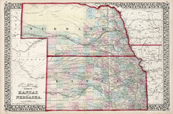
W.H. Gamble. "County & Township Map of the States of Kansas and Nebraska."
Philadelphia: S. Augustus Mitchell, Jr., 1874. 14 1/8 x 21 3/8. Lithograph. Original hand color. Very good condition.
A Mitchell map of the two states as they were configured shortly after statehood and the completion of the transcontinental railroad. Kansas, through which the Pacific Railroad ran, was highly developed at this point, as can been clearly seen here. The Pacific R.R. is shown, as is the Atchison, Topeka & Sante Fe R.R., and a few others in the state, bringing considerable growth of towns, roads, and so forth. Nebraska shows the Union Pacific Railroad passing through, but development is considerably less, limited mostly to the east and south of the Platte River. An excellent early picture of these two plains states.
 %20%0A%20%0Ahttps://philaprintshop.com/products/gamble-w-h-county-township-map-of-the-states-of-kansas-and-nebraska %20%0A%20%0AGamble,%20W.H.%20%22County%20%26%20Township%20Map%20of%20the%20States%20of%20Kansas%20and%20Nebraska%22 %20%0A%20%0A//philaprintshop.com/cdn/shop/files/mitchksnb74_1024x1024.jpg?v=1706816930 %20%0A%20%0AAntique Prints, Maps, Drawings, Paintings and Rare Books! %20%0A%20%0AThe Philadelphia Print Shop %20%0A106 E. Lancaster Avenue, Lower Level %20%0AWayne, PA 19087 %20%0A%20%0APhilaPrintShop.com %20%0A@PhiladelphiaPrintShop %20%0A 610 (808) 6165)