


W.H. Gamble. "County Map of Minnesota." From Mitchell's New General Atlas.
Philadelphia: S. Augustus Mitchell, Jr., 1872 14 x 11 1/2. Lithograph. Hand colored. Very good condition.
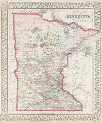
S.Augustus Mitchell, Jr., of Philadelphia, was one of the largest map publishers of the middle of the nineteenth century. The firm was founded by his father, who from the middle of the nineteenth century, issued atlases and maps of all parts of the world in all formats. The Mitchell atlases contained up-to-date maps which were as attractive as they were accurate. This is a fine example of the Mitchell firm's output, showing Minnesota in 1872. This was a period of significant development and growth in the state, as documented by the dense settlement in the southeast. Of note also are the many railroads shown crossing the state, mostly in the southern parts.
 %20%0A%20%0Ahttps://philaprintshop.com/products/gamble-w-h-county-map-of-minnesota %20%0A%20%0AGamble,%20W.H.%20%22County%20Map%20of%20Minnesota%22 %20%0A%20%0A//philaprintshop.com/cdn/shop/files/mitchellmn1872c_1024x1024.jpg?v=1686161194 %20%0A%20%0AAntique Prints, Maps, Drawings, Paintings and Rare Books! %20%0A%20%0AThe Philadelphia Print Shop %20%0A106 E. Lancaster Avenue, Lower Level %20%0AWayne, PA 19087 %20%0A%20%0APhilaPrintShop.com %20%0A@PhiladelphiaPrintShop %20%0A 610 (808) 6165)