

J.H. Colton. "Kansas and Nebraska."
New York: J.H. Colton, 1863. 25 1/4 x 16 3/4. Lithograph. Original hand-coloring. Narrow margins around decorative border, with some chipping just in corners. Otherwise, very good condition.
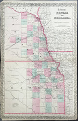
A map of the eastern parts of Nebraska and Kansas issued shortly after they took on their present-day shapes. The territories of Nebraska and Kansas were created in 1854 out of the old Missouri Territory. In 1861, Kansas attained statehood, while the Nebraska Territory lost two-thirds of its land to the newly created Dakota Territory, though it still extended to the Rocky Mountains. The western parts, beyond the 104th meridian, were detached from Nebraska in 1863, thus attaining its present configuration. This map, issued about this time, shows just the eastern parts of Nebraska and Kansas, as there was almost no development in the western parts. Detail is very good of this area, with counties, towns, rivers, Indian reservations, roads and forts clearly indicated and named. Of particular interest are the depictions of the old Santa Fe trail and the "Pony Express and U.S. Mail Route," both heading west off the map.
 %20%0A%20%0Ahttps://philaprintshop.com/products/colton-j-h-kansas-and-nebraska %20%0A%20%0AColton,%20J.H.%20%22Kansas%20and%20Nebraska%22 %20%0A%20%0A//philaprintshop.com/cdn/shop/files/coltonksneb_1024x1024.jpg?v=1706820937 %20%0A%20%0AAntique Prints, Maps, Drawings, Paintings and Rare Books! %20%0A%20%0AThe Philadelphia Print Shop %20%0A106 E. Lancaster Avenue, Lower Level %20%0AWayne, PA 19087 %20%0A%20%0APhilaPrintShop.com %20%0A@PhiladelphiaPrintShop %20%0A 610 (808) 6165)