


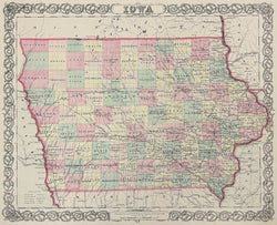
J.H. Colton. “Iowa.”
New York: J.H. Colton & Co., 1856. 12 3/4 x 15 3/4. Lithograph. Full original hand-coloring. With decorative strap work border. No text on verso. Accompanying text page about the state included, but separate. Very good condition.
In the mid-nineteenth century, the center of map publishing in America moved from Philadelphia to New York. The J.H. Colton publishing firm played a large role in this shift. This map of Iowa, with its fine detail, is a strong example of their successful work. The map presents the counties in contrasting pastel shades, and includes depictions of towns, rivers, marshes, and some topography. Of particular interest are the indications of the burgeoning transportation network in the state, with roads and railroads clearly shown, especially in the eastern part of the state and along the southern tier, connecting Des Moines with Omaha City and Elkhorn City in Nebraska. An attractive map as well as a worthwhile historical document.
 %20%0A%20%0Ahttps://philaprintshop.com/products/colton-j-h-iowa %20%0A%20%0AColton,%20J.H.%20%22Iowa%22 %20%0A%20%0A//philaprintshop.com/cdn/shop/files/colton56iac_1024x1024.jpg?v=1700603673 %20%0A%20%0AAntique Prints, Maps, Drawings, Paintings and Rare Books! %20%0A%20%0AThe Philadelphia Print Shop %20%0A106 E. Lancaster Avenue, Lower Level %20%0AWayne, PA 19087 %20%0A%20%0APhilaPrintShop.com %20%0A@PhiladelphiaPrintShop %20%0A 610 (808) 6165)