


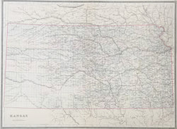
W.M. Bradley. “Kansas.”
Philadelphia: W.M. Bradley & Bro., 1884. 16 3/8 x 22 1/4. Lithograph. Original hand color. Very good condition.
A precisely detailed map from the Philadelphia publishing firm of William M. Bradley & Bro. This Kansas map is a fine example of nineteenth century American mapmaking. It shows the state in impressive detail, with emphasis on rivers, towns, and the myriad railroad lines criss-crossing the state. Counties are delineated with attractive, light pastel colors. Interestingly, although this map was published in 1884 and does show counties in the northwest created in 1873, it does not show several southwestern counties created in the same year.
 %20%0A%20%0Ahttps://philaprintshop.com/products/bradley-w-m-kansas %20%0A%20%0ABradley,%20W.M.%20%E2%80%9CKansas.%E2%80%9D %20%0A%20%0A//philaprintshop.com/cdn/shop/files/bradleykanthmb_1024x1024.jpg?v=1706821731 %20%0A%20%0AAntique Prints, Maps, Drawings, Paintings and Rare Books! %20%0A%20%0AThe Philadelphia Print Shop %20%0A106 E. Lancaster Avenue, Lower Level %20%0AWayne, PA 19087 %20%0A%20%0APhilaPrintShop.com %20%0A@PhiladelphiaPrintShop %20%0A 610 (808) 6165)