


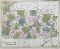
Thomas G. Bradford. “Pennsylvania.”
From A Universal Illustrated Atlas. Boston: Charles D. Strong, 1838. 11 3/8 x 14. Engraving by G.W. Boynton. Original hand color. Stains in margins away from image. Else, very good condition.
A finely engraved map by Thomas G. Bradford, a Boston map publisher, showing Pennsylvania in the third decade of the nineteenth century. The first half of the nineteenth century was a time of considerable growth for the Keystone State and this map illustrates the social, political and transportation situation at the time. Counties are named and indicated in contrasting shades, and rivers, lakes, and towns are precisely depicted. The burgeoning road, railroad and canal network is clearly indicated throughout. The strong colors used are particularly appealing, making this a nice picture of Pennsylvania just before mid-century.
 %20%0A%20%0Ahttps://philaprintshop.com/products/bradford-thomas-g-pennsylvania %20%0A%20%0ABradford,%20Thomas%20G.%20%20%E2%80%9CPennsylvania%E2%80%9D %20%0A%20%0A//philaprintshop.com/cdn/shop/files/bradfordpac_1024x1024.jpg?v=1698863018 %20%0A%20%0AAntique Prints, Maps, Drawings, Paintings and Rare Books! %20%0A%20%0AThe Philadelphia Print Shop %20%0A106 E. Lancaster Avenue, Lower Level %20%0AWayne, PA 19087 %20%0A%20%0APhilaPrintShop.com %20%0A@PhiladelphiaPrintShop %20%0A 610 (808) 6165)