

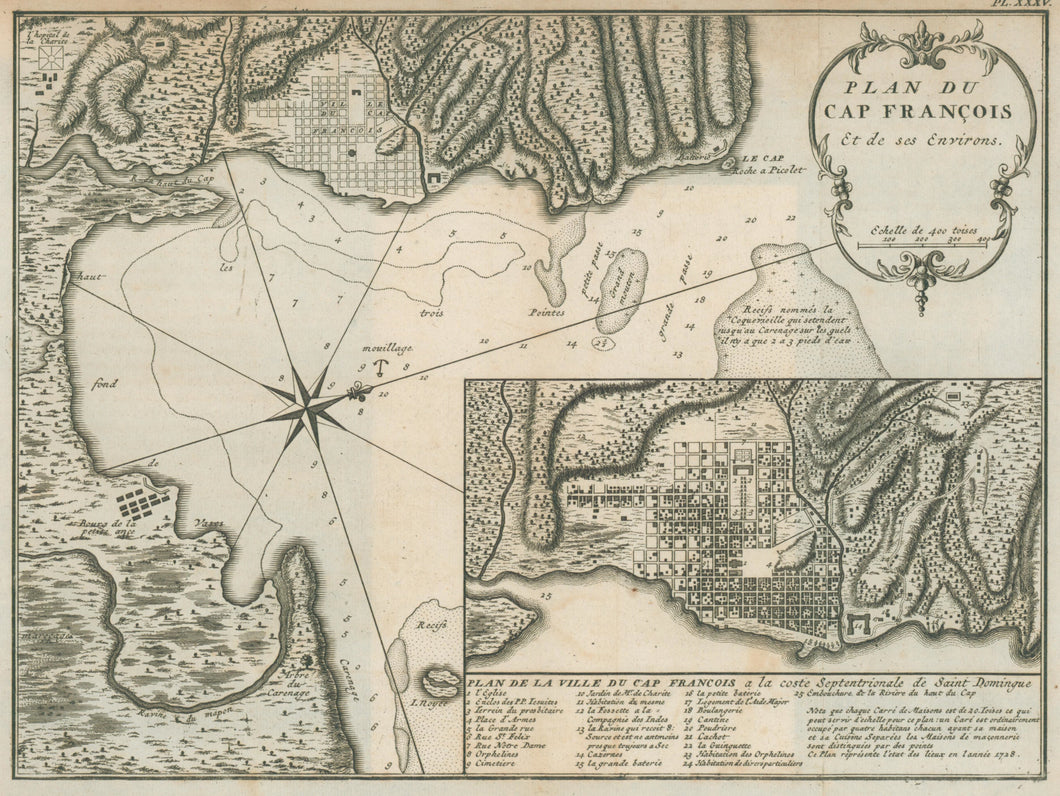


Unattributed. "Plan du Cap François et de ses Environs," with inset "Plan de la Ville du Cap François a la coste Septentrionale de Saint Domingue." From Antonio de Ulloa and Jorge Juan y Santacilla. Voyage Historique de l'Amerique Meridionale.
Amsterdam and Leipzig, 1752. 9 x 12 1/4. Copper engraving. Very good condition. Sabin, 36812.
Ulloa's and Juan y Santacilla's narrative was by two Spanish members of an important mid-eighteenth century scientific expedition to South America. Under the auspices of the Academy of Sciences at Paris, an expedition was sent to Peru in 1735 under the command of Charles La Condamine to take an exact measurement of a degree of longitude. The King of Spain lent his support to the venture by sending along Don Ulloa and Don Juan. This expedition completed its task under conditions of unequalled difficulty, and the story of the trip provides fascinating reading. Here is one of the maps which appeared in one of the many editions published in the eighteenth century.
 %20%0A%20%0Ahttps://philaprintshop.com/products/unattributed-plan-du-cap-francois-et-de-ses-environs-with-inset-plan-de-la-ville-du-cap-francois-a-la-coste-septentrionale-de-saint-domingue %20%0A%20%0AUnattributed%20%22Plan%20du%20Cap%20Fran%C3%A7ois%20et%20de%20ses%20Environs,%22%20with%20inset%20%22Plan%20de%20la%20Ville%20du%20Cap%20Fran%C3%A7ois%20a%20la%20coste%20Septentrionale%20de%20Saint%20Domingue%22 %20%0A%20%0A//philaprintshop.com/cdn/shop/products/ulloacapfranc_1024x1024.jpg?v=1678221347 %20%0A%20%0AAntique Prints, Maps, Drawings, Paintings and Rare Books! %20%0A%20%0AThe Philadelphia Print Shop %20%0A106 E. Lancaster Avenue, Lower Level %20%0AWayne, PA 19087 %20%0A%20%0APhilaPrintShop.com %20%0A@PhiladelphiaPrintShop %20%0A 610 (808) 6165)