


Raymond Bonheur (1796 - 1849). “Colonies Françaises. Martinique Amerique du Sud.” From Victor Levasseur’s Atlas National illustre des 86 departments et des possessions de la France, divise par arrondissements, cantons, et communes avec le trace de toutes les routes, chemins de fer et canaux.
Paris: A. Combetti, 1847. 10 ½ x 16. Steel engraving with hand coloring. Very good condition.
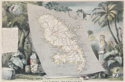
An interesting map of the French colonies in America from a series of precisely drawn maps issued in Paris in the mid-nineteenth century. The map shows the topography and political divisions of Guyana, St. Martin, Newfoundland, and St. Pierre & Miquelon. The cartography is enhanced by statistical tables on each colony. However, the most outstanding feature of the map is the superb, embellished decorative border. Through allegory and symbols, this border further tells the story of the history and economies of the colonies. For visual appeal as well as insights offered, this is an excellent nineteenth-century French map.
 %20%0A%20%0Ahttps://philaprintshop.com/products/copy-of-delisle-buache-carte-de-lisle-de-la-martinique %20%0A%20%0ABonheur,%20Raymond%20%22Colonies%20Fran%C3%A7aises.%20Martinique%20Amerique%20du%20Sud%22 %20%0A%20%0A//philaprintshop.com/cdn/shop/products/levasseur-martiniquec_1024x1024.jpg?v=1677793661 %20%0A%20%0AAntique Prints, Maps, Drawings, Paintings and Rare Books! %20%0A%20%0AThe Philadelphia Print Shop %20%0A106 E. Lancaster Avenue, Lower Level %20%0AWayne, PA 19087 %20%0A%20%0APhilaPrintShop.com %20%0A@PhiladelphiaPrintShop %20%0A 610 (808) 6165)