
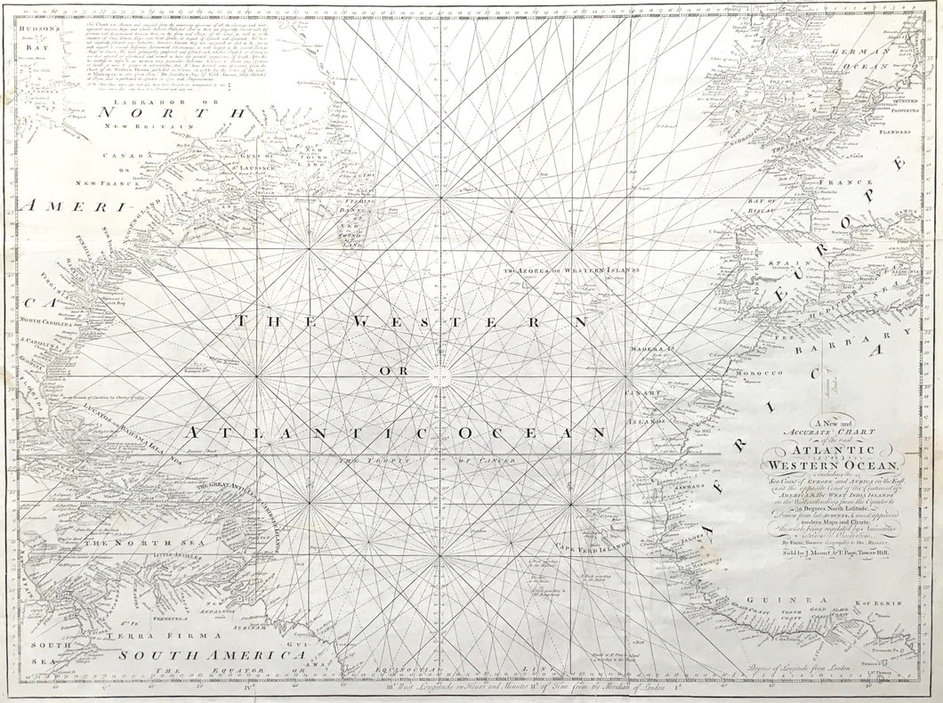
Emanuel Bowen. "A New and Accurate Chart of the vast Atlantic or Western Ocean, including the Sea Coast of Europe and Africa on the East and the opposite Coast of the Continent of America and the West Indies Islands on the West extending from the Equator to 59 Degrees North Latitude."
Line engraving. London: Mount & Page, 1778. 23 1/4 x 30 1/2 (neatlines) plus complete margins. National Maritime Museum Catalogue of the Library, p. 490. Excellent.
For over a hundred years the atlas known as The English Pilot continued to be published amid complaints from seamen that it was out of date. Changes were slow to appear even as Mount & Page took over from John Seller who had started it in 1671. Despite complaints, the charts continued to sell because they were inexpensive, and captains of small packets or other trading vessels could not afford better. This chart of the entire Atlantic Ocean exhibits the primitive look of the old English Pilot format, but it contains the improvements introduced by Edmund Halley earlier in the eighteenth century. Emanuel Bowen prepared this chart for Mount & Page, and it is first found in an atlas of 1778, probably to meet the demands of cross ocean travel during the American Revolution. Known as The Fourth Book, the American edition went through fourteen editions between 1689 and 1789, so this is one of the later maps. Comparing it to works by William Faden, Sayer & Bennett, or J.F.W. DesBarres would illustrate why not many were produced, fewer were sold, and many would have been lost with the poorer ships that carried them. Still, this is a dramatic sea chart with its strong rhumb lines and profuse coastal information. This is the tool that would have guided ships with slaves from Africa, food stuffs from the Mediterranean, and hardware from western Europe. A scarce and wonderful index map to a major atlas.
 %20%0A%20%0Ahttps://philaprintshop.com/products/bowen-emanuel-a-new-and-accurate-chart-of-the-vast-atlantic-or-western-ocean %20%0A%20%0ABowen,%20Emanuel%20%20%22A%20New%20and%20Accurate%20Chart%20of%20the%20vast%20Atlantic%20or%20Western%20Ocean...%22 %20%0A%20%0A//philaprintshop.com/cdn/shop/products/bowenatlantic_1024x1024.jpg?v=1614811371 %20%0A%20%0AAntique Prints, Maps, Drawings, Paintings and Rare Books! %20%0A%20%0AThe Philadelphia Print Shop %20%0A106 E. Lancaster Avenue, Lower Level %20%0AWayne, PA 19087 %20%0A%20%0APhilaPrintShop.com %20%0A@PhiladelphiaPrintShop %20%0A 610 (808) 6165)