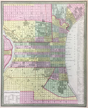
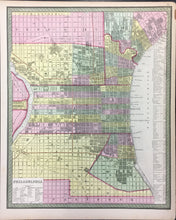
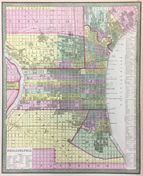
Henry S. Tanner. Plate 14. “Philadelphia.” From A New Universal Atlas…
Philadelphia: Cowperthwait, Desilver & Butler, 1854. 15 3/4 x 12 3/4. Lithographic transfer from engraved plate. Full original hand coloring. Minor stain in upper right hand and bottom margin. Very good condition.
A crisp, detailed map of the city of Philadelphia by the great American cartographer, Henry Schenck Tanner. Beginning in 1819, Tanner published his American Atlas, which was a huge success. This inspired Tanner to produce his Universal Atlas, of more manageable size, which contained fine maps of each state and a number of cities. These maps were purchased by S. Augustus Mitchell, and then about 1850 by Cowperthwait, Desilver & Butler, who continued to issue updated versions of the atlas. This map of Philadelphia is an excellent example of Tanner’s cartography. The city is shown from Kensington to Southwark, and from the Delaware to just into West Philadelphia. It illustrates and gives an index of the more important buildings in the city. The north-south running streets west of Penn Square are identified as Schuylkill Front to Eight Streets; these streets were later re-named counting from the Delaware. Another interesting aspect of this map is that the developed portions of the city have been shaded. This allows one to see the extent of the inhabited areas of the city at the time. Tanner’s maps are always noted for their focus on transportation, and this map is no exception. It shows early rail line routes, canals, and indicates the ferry lines on the Delaware. An inset in the lower left gives a key to the city wards. Besides its fascinating detail, the map is most attractive, with its striking design enhanced by strong hand color. Overall, a most desirable map of the city.


