

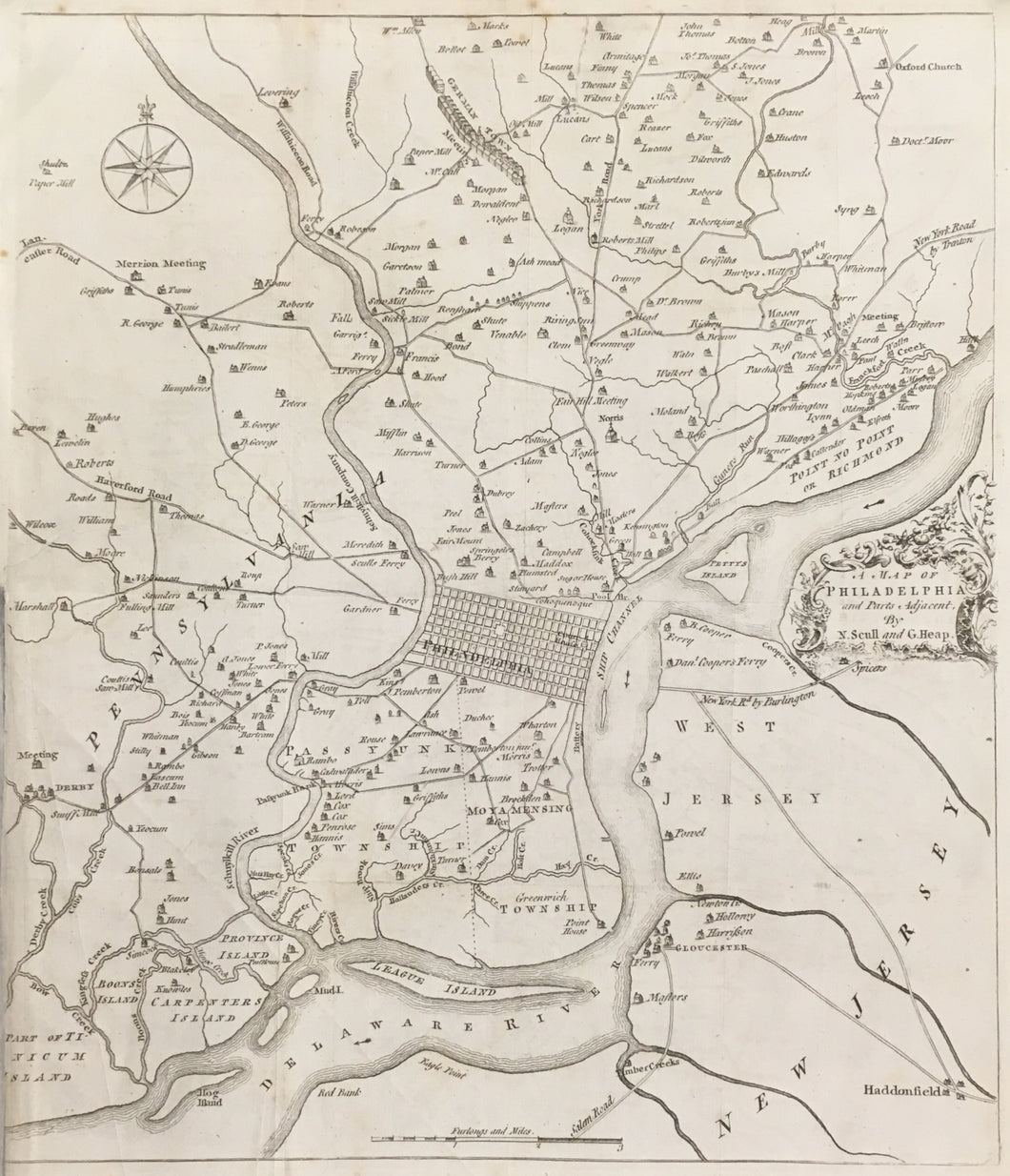


Nicholas Scull (1686-1762) & George Heap (1714-1752). “A Map of Philadelphia and Parts Adjacent.”
London: Gentleman’s Magazine, February 1777. Second edition. 13 1/2 x 11 1/2. Engraving. Folds as issued. Repaired short tear into map left hand side. Left hand margin partially re-margined. Bottom half of left hand margin trimmed just into plate mark. Chipping in upper left hand margin. Else, very good condition. Prints of Philadelphia, 10; Snyder: 16A. A/A
Perhaps the most famous map of Philadelphia, the Scull & Heap map went through many editions beginning in 1752. Originally the map was issued as a promotion piece for Penn’s city and province in America, and with that purpose in mind a reduced version was issued in 1753 in the London periodical Gentleman’s Magazine. Just over two decades later, Philadelphia became the political center of the turmoil surrounding the American War of Independence, and together with the British occupation, these circumstances created renewed interest in the City of Brotherly Love. The Scull & Heap map was still the best available of Philadelphia, so the publishers of Gentleman’s Magazine reissued the map in a slightly updated form in December, 1777. For the second edition the vertical distance key was burnished out on the right hand side in New Jersey and new topographical information was engraved.
Holme’s grid plan for Philadelphia itself lies at the center of the map, with the open Center Square and the Court House the only indicated features. More information is given of the surrounding regions, where roads, mills, and houses of prominent citizens are shown and named. Of some note is interesting depiction of Germantown, with houses lining both sides of Germantown Pike. As the settlements in New Jersey to the east of Philadelphia had considerably developed over the previous two decades, this version of the map added roads and settlement information there. As the events of 1777 and 1778 unfolded, this widely disseminated map would have provided most of the English public with their only view on the geography of the city, and likewise it provides us with a unique view of the city over two centuries ago. It is a classic piece of Philadelphiana from the Revolutionary War period.
 %20%0A%20%0Ahttps://philaprintshop.com/products/scull-nicholas-george-heap-a-map-of-philadelphia-and-parts-adjacent-1777 %20%0A%20%0AScull,%20Nicholas%20%26%20George%20Heap%20%22A%20Map%20of%20Philadelphia%20and%20Parts%20Adjacent%22%201777 %20%0A%20%0A//philaprintshop.com/cdn/shop/files/dallettscullheap1777c_1024x1024.jpg?v=1686256031 %20%0A%20%0AAntique Prints, Maps, Drawings, Paintings and Rare Books! %20%0A%20%0AThe Philadelphia Print Shop %20%0A106 E. Lancaster Avenue, Lower Level %20%0AWayne, PA 19087 %20%0A%20%0APhilaPrintShop.com %20%0A@PhiladelphiaPrintShop %20%0A 610 (808) 6165)