


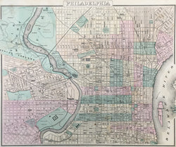
O.W. Gray. “Philadelphia.”
Philadelphia: Stedman, Brown & Lyon, ca. 1872. 12 X 17. Lithograph. Original hand color. Full margins. Minor time toning and soiling/staining in margins. Very good condition.
A handsome and detailed map of Philadelphia by O.W. Gray. Gray began issuing atlases around mid-century and continued, first on his own and later as O.W. Gray & Son to the 1880s. This map shows Philadelphia about a decade after the end of the Civil War, when Philadelphia was an impressive urban center, the fourth largest city in the world. Most of its important structures were located in what is now known as “Center City.” This clear map focuses on that section, extending from Norris to Morris, and from the eastern bank of the Delaware to the western bank of the Schuylkill. The map depicts and names streets, rail lines, and major buildings. Each ward is colored in a contrasting, light pastel shade.
 %20%0A%20%0Ahttps://philaprintshop.com/products/gray-o-w-philadelphia-1 %20%0A%20%0AGray,%20O.W.%20%20%E2%80%9CPhiladelphia%E2%80%9D %20%0A%20%0A//philaprintshop.com/cdn/shop/files/grayphila1872thmb_1024x1024.jpg?v=1718380309 %20%0A%20%0AAntique Prints, Maps, Drawings, Paintings and Rare Books! %20%0A%20%0AThe Philadelphia Print Shop %20%0A106 E. Lancaster Avenue, Lower Level %20%0AWayne, PA 19087 %20%0A%20%0APhilaPrintShop.com %20%0A@PhiladelphiaPrintShop %20%0A 610 (808) 6165)