


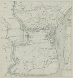
After William Faden. “A Plan of The City and Environs of Philadelphia with the Works and Encampments of His Majesty’s Forces Under the Command of of Lieutenant General Sir William Howe, K.B.” From Thomas Scharf and Thompson Westcott History of Philadelphia, 1609-1884.
Philadelphia: L. H. Everts & Co., 1884. 11 ¾ x 8 1/8 (includes title). Lithographic facsimile on thin bank note/chine appliqué paper. With folds as originally issued. Very good condition.
A fine 19th century facsimile map of William Faden’s rare and important series of Revolutionary War battle maps. This Faden map shows the situation of the British forces during their stay in Philadelphia from 1777 to 1778, based on a sketch probably drawn by Pierre Nicole. It depicts the area extending from a ford on the Schuylkill north of Fairmount to the mouth of the river where it empties into the Delaware. Roads, streams, rivers, and general topography are illustrated, along with homes of prominent families in the countryside. Faden did not use Holmes’ ideal grid plan, but instead drew the city as it actually existed in 1777, extending to just beyond Eighth Street in the west, and from Callowhill Street in the north to Christian Street in the south. Major public buildings are indicated, including the State House, the Gaol, Christ Church, etc., all of which are identified in a key at the top of the map. The location of the British fortifications around the city are depicted and named.
This map is a lithographic facsimile printed in 1884 for a three volume set of the History of Philadelphia comprising 2,399 pages and organized in 59 chapters. Scharf & Westcott’s massive work is the standard reference for Philadelphia history up to its date of publication containing this map and over 430 illustrations, including portraits, parks, houses, businesses, institutions, and the like.
 %20%0A%20%0Ahttps://philaprintshop.com/products/faden-william-a-plan-of-the-city-and-environs-of-philadelphia-with-the-works-and-encampments-of-his-majesty-s-forces-under-the-command-of-of-lieutenant-general-sir-william-howe-k-b %20%0A%20%0AFaden,%20William%20%E2%80%9CA%20Plan%20of%20The%20City%20and%20Environs%20of%20Philadelphia%20with%20the%20Works%20and%20Encampments%20of%20His%20Majesty%E2%80%99s%20Forces%20Under%20the%20Command%20of%20of%20Lieutenant%20General%20Sir%20William%20Howe,%20K.B.%E2%80%9D %20%0A%20%0A//philaprintshop.com/cdn/shop/products/philafadenfacsimilec_1024x1024.jpg?v=1630769093 %20%0A%20%0AAntique Prints, Maps, Drawings, Paintings and Rare Books! %20%0A%20%0AThe Philadelphia Print Shop %20%0A106 E. Lancaster Avenue, Lower Level %20%0AWayne, PA 19087 %20%0A%20%0APhilaPrintShop.com %20%0A@PhiladelphiaPrintShop %20%0A 610 (808) 6165)