

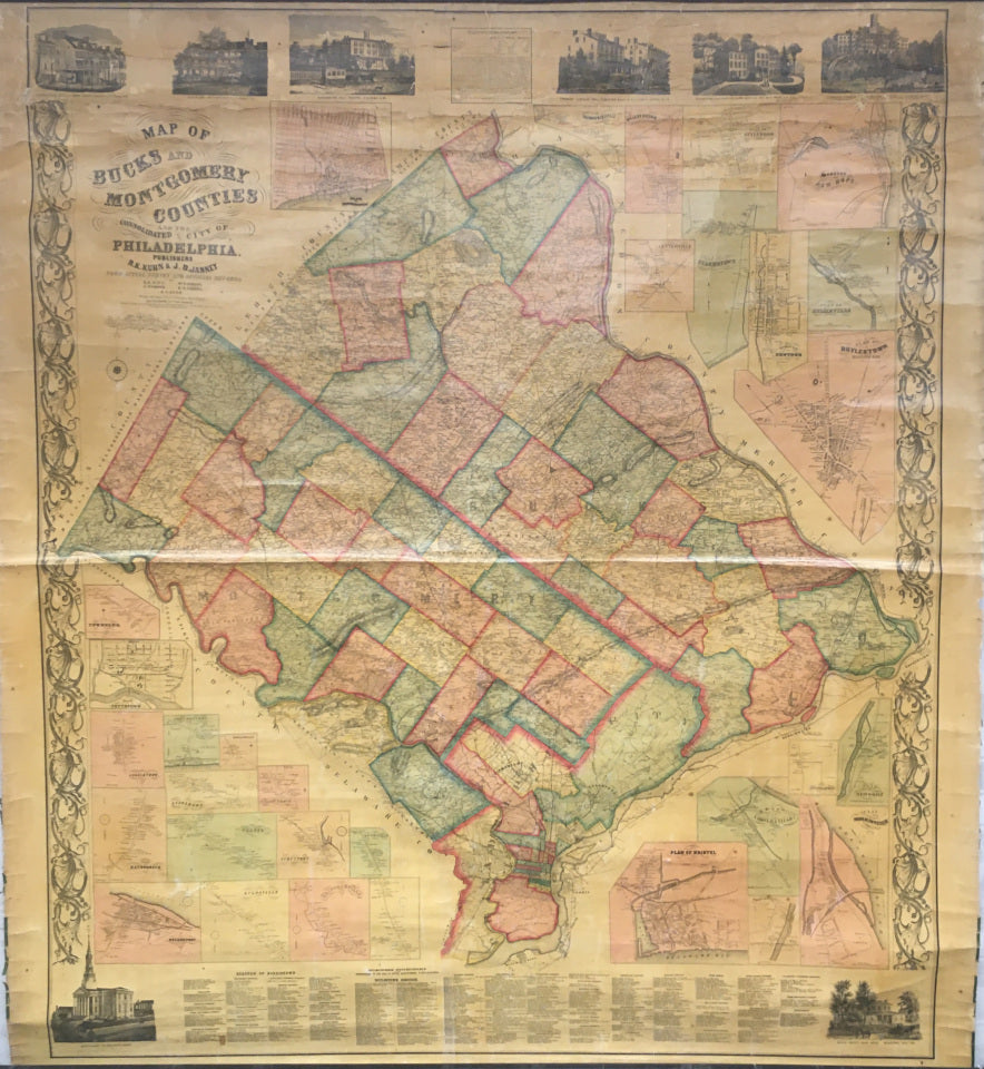


Kuhn & Janney. "Map of Bucks and Montgomery Counties and the Consolidated City of Philadelphia."
Philadelphia: R. K. Kuhn & J. D. Janney, 1857. Wagner & McGuigan Lithographers. 61 x 52. Original hand color, with townships and city wards in contrasting shades. Separately issued wall map. Cracks to surface. Top 12" reinforced with archival paper. With original rollers and ribbons. Overall good condition. Peters, America on Stone, pp. 393-95.
Eight inset woodcut views: Krams Hotel, Doylestown, Bucks County; Browers Hotel, Doylestown, Bucks County; Washington Hall, Trappe; Tremont Seminary (male), Norristown, Montgomery County; Cottage Female Seminary, Pottstown, Montgomery County; Oakland Female Institute, Norristown, Montgomery County; Montgomery County Court House; Bucks County Court House, Doylestown.
Thirty one inset maps: "Plan of Norristown," "Trombowersville," "Fallsington," Plan of Attleboro," "Borough of New Hope," "Centerville," "Quakertown," "Borough of Newtown," "Plan of Hulmeville," "Plan of Doylestown Borough," "Townsend," "Plan of Pottstown," "Jenkintown," "Port Kennedy," "Harleysville," "Plan of Hatborough," "Evansburgh," "Willow Grove," "Trappe," "Sumneytown," "Greenville," "Bridgeport," "Kulpsville," "Skippackville," "Pennsburg," "Plan of Bristol," "Plan of Yardleyville," "Applebachville," "Plan of Newport," "Bridgewater," and "Plan of Morrisville."
Main map and inset maps detail an impressive number of landholders identifying the location of heads-of households, making this a valuable primary resource for genealogists or anyone researching this area in Southeast Pennsylvania.

 %20%0A%20%0Ahttps://philaprintshop.com/products/copy-of-lloyd-j-t-lloyds-topographical-and-railway-map-of-north-america %20%0A%20%0AKuhn%20%26%20Janney.%20%20%22Map%20of%20Bucks%20and%20Montgomery%20Counties%20and%20the%20Consolidated%20City%20of%20Philadelphia%22 %20%0A%20%0A//philaprintshop.com/cdn/shop/products/kuhnbucksmontcoc_1024x1024.jpg?v=1649185474 %20%0A%20%0AAntique Prints, Maps, Drawings, Paintings and Rare Books! %20%0A%20%0AThe Philadelphia Print Shop %20%0A106 E. Lancaster Avenue, Lower Level %20%0AWayne, PA 19087 %20%0A%20%0APhilaPrintShop.com %20%0A@PhiladelphiaPrintShop %20%0A 610 (808) 6165)