
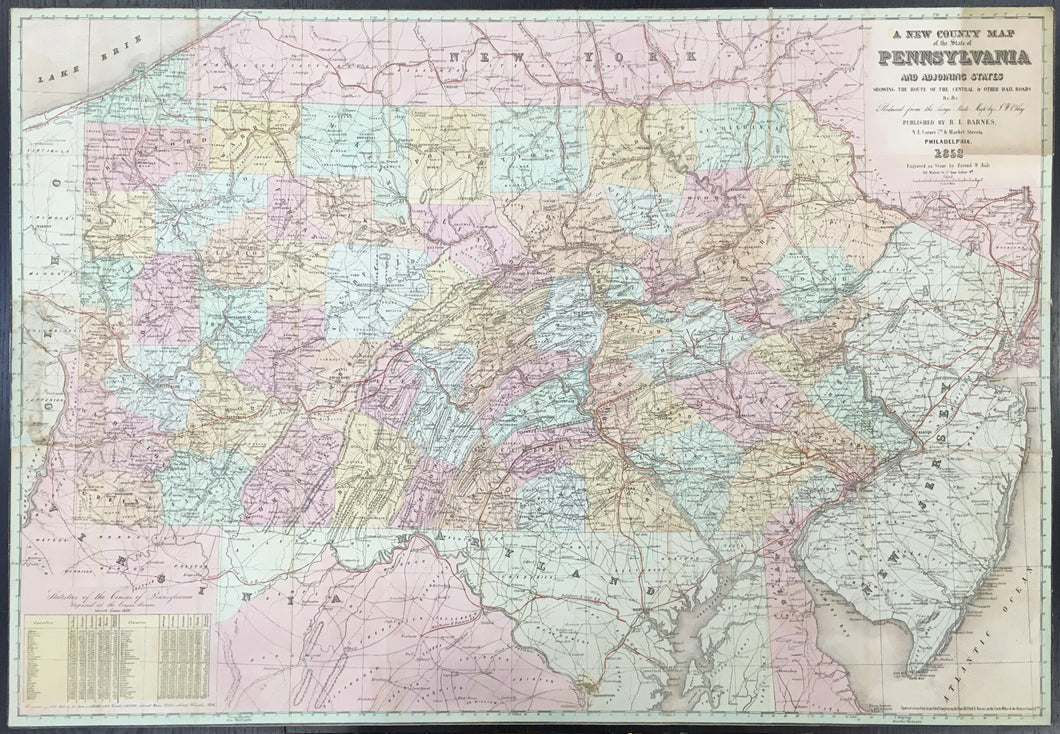
“A New County Map of the State of Pennsylvania and adjoining states showing the route of the Central and other rail roads..."
Philadelphia: R.L. Barnes, 1852. Separately issued, folding map on bank note paper. 25 1/4 x 36 1/2. Lithographed by Friend & Aub. Full, original hand color. Trimmed to neat line as issued. Rectangular toning in upper right hand corner where folding map came in contact with front cover. Light scattered glue stains left hand side of map where map was attached to back cover. Also a small loss of map information in this area professionally filled with rice paper and in-painted. Overall, very good condition and appearance.
A rare and most interesting folding pocket map of Pennsylvania from just after the middle of the nineteenth century. The first official state map was John Melish's 1822 issue, which was updated by William Morris in 1848. Within just a few years, J.W. Otley, about whom little is known, produced another large state map, probably based on his own new surveys. The Otley map was reduced and issued in 1852 by R.L. Barnes and then again in 1853. This is a fine example of that first issue. As noted in the title, this map specifically was intended to illustrate the then rapidly developing railroad network in Pennsylvania, and this may be the reason that Barnes used Otley's map for his new publication, instead of the Melish-Morris map, in order to show this important transportation information which the earlier mapping would not have contained. This map does show very detailed information on the railroads throughout, as well as roads, towns, rivers and much other topography. It would have made a fine traveler's map or a map for reference by businessmen.
 %20%0A%20%0Ahttps://philaprintshop.com/products/otley-j-w-a-new-county-map-of-the-state-of-pennsylvania %20%0A%20%0AOtley,%20J.%20W.%20%20%E2%80%9CA%20New%20County%20Map%20of%20the%20State%20of%20Pennsylvania...%22 %20%0A%20%0A//philaprintshop.com/cdn/shop/files/otleypa1852_1024x1024.jpg?v=1711479770 %20%0A%20%0AAntique Prints, Maps, Drawings, Paintings and Rare Books! %20%0A%20%0AThe Philadelphia Print Shop %20%0A106 E. Lancaster Avenue, Lower Level %20%0AWayne, PA 19087 %20%0A%20%0APhilaPrintShop.com %20%0A@PhiladelphiaPrintShop %20%0A 610 (808) 6165)