


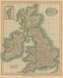
John Cary. “British Isles.” From Cary’s New Universal Atlas.
London: J. Cary, 1816. Ca. 9 x 11. Engraving by John Cary. Original hand color. With some scattered, light foxing. Otherwise, very good condition.
A map from a series of detailed, quarto-sized maps of all parts of the world by John Cary (ca. 1754-1835), the founder of the famous English cartographic firm. From about mid-way through the eighteenth century, British cartographers were the best in the world, and the maps produced by Cary are good examples of the quality they achieved. Rivers, towns, roads, and other information is clearly presented with very crisp engravings, and the maps have an almost three-dimensional topographical appearance. The European maps in this series are of particular interest because Cary shows the results of the Congress of Vienna. It was there that the victorious powers from the Napoleonic Wars met to settle the borders of post-war Europe, and the treaty that finalized these deliberations was signed just the year before this atlas was issued. The subtle hand coloring adds a decorative touch to these fine early nineteenth century historic documents.
 %20%0A%20%0Ahttps://philaprintshop.com/products/cary-john-british-isles %20%0A%20%0ACary,%20John%20%E2%80%9CBritish%20Isles%E2%80%9D %20%0A%20%0A//philaprintshop.com/cdn/shop/files/carybritishislesc_1024x1024.jpg?v=1682714331 %20%0A%20%0AAntique Prints, Maps, Drawings, Paintings and Rare Books! %20%0A%20%0AThe Philadelphia Print Shop %20%0A106 E. Lancaster Avenue, Lower Level %20%0AWayne, PA 19087 %20%0A%20%0APhilaPrintShop.com %20%0A@PhiladelphiaPrintShop %20%0A 610 (808) 6165)