


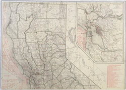
Rand McNally. "Standard Map of California." (Northern).
From Commercial Atlas of America. 1925. 18 3/4 x 26. Cereograph. Key of California railroad lines. With inset map of San Francisco & Vicinity. Very good condition.
An early twentieth century map from Rand, McNally & Co. firm out of Chicago, a company that would shift the center of cartographic publishing from the east coast to the mid-west. Typical of the firm’s work, this map has very good detail precisely and neatly exhibited. Topographic and social information, counties, roads, and many more details are neatly illustrated.
 %20%0A%20%0Ahttps://philaprintshop.com/products/rand-mcnally-standard-map-of-california-northern %20%0A%20%0ARand%20McNally%20%22Standard%20Map%20of%20California%22%20(Northern) %20%0A%20%0A//philaprintshop.com/cdn/shop/files/randnorthcathmb_1024x1024.jpg?v=1707416632 %20%0A%20%0AAntique Prints, Maps, Drawings, Paintings and Rare Books! %20%0A%20%0AThe Philadelphia Print Shop %20%0A106 E. Lancaster Avenue, Lower Level %20%0AWayne, PA 19087 %20%0A%20%0APhilaPrintShop.com %20%0A@PhiladelphiaPrintShop %20%0A 610 (808) 6165)