

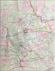
J.L. Smith. "Smith's New Map of Philadelphia and Vicinity".
Philadelphia: J.L. Smith, 1875. Lithograph on thin bank note paper. 13 x 21. With folds as originally issued. One part of a two part separately issued folding map, with original gold stamped buckram front cover. A number of repaired tears along folds with some small areas filled and in painted. Else, fine condition.
One half of a large map of Philadelphia and the region. This map depicts only the western part of the Philadelphia suburbs which extends from Upper Providence Township in Montgomery County down to the Delaware State border and from the western end of Radnor Township to West Bradford Township in Chester County. Extensive information is given for these areas including roads, rivers, rail lines, mills, hotels, meeting houses, and myriad other geographic details.
 %20%0A%20%0Ahttps://philaprintshop.com/products/smith-j-l-smiths-new-map-of-philadelphia-and-vicinity %20%0A%20%0ASmith,%20J.L.%20%22Smith's%20New%20Map%20of%20Philadelphia%20and%20Vicinity%22 %20%0A%20%0A//philaprintshop.com/cdn/shop/products/ScreenShot2021-04-12at2.48.14PM_1024x1024.png?v=1618260586 %20%0A%20%0AAntique Prints, Maps, Drawings, Paintings and Rare Books! %20%0A%20%0AThe Philadelphia Print Shop %20%0A106 E. Lancaster Avenue, Lower Level %20%0AWayne, PA 19087 %20%0A%20%0APhilaPrintShop.com %20%0A@PhiladelphiaPrintShop %20%0A 610 (808) 6165)