![Sanborn Map Co. Plate 10. [North Wayne, PA: North Wayne Ave. to Woodland Ave. & Walnut Ave. to E. Eagle Rd]](http://philaprintshop.com/cdn/shop/files/sanbornwayne10_{width}x.jpg?v=1705425851)
![Sanborn Map Co. Plate 10. [North Wayne, PA: North Wayne Ave. to Woodland Ave. & Walnut Ave. to E. Eagle Rd]](http://philaprintshop.com/cdn/shop/files/sanbornwayne10_530x@2x.jpg?v=1705425851)
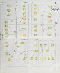
Sanborn Map Co. Plate 10. [North Wayne, PA: North Wayne Ave. to Woodland Ave. & Walnut Ave. to E. Eagle Rd]. From Sanborn’s Fire Insurance Atlas of Wayne-St. Davids, Delaware County, Pennsylvania.
New York: Sanborn Map Co., [1930]-1935. 25 ½ x 21 (sheet). Lithograph on parchment type paper. Original color. Center fold as issued. Very good condition. Scarce.
We have many more maps from this atlas. Please contact us for more information and/or photographs.
The Sanborn Map Company published detailed and large scale maps of towns and cities in the United States from the mid 19th century to late 20th century. These maps were created to allow fire insurance companies to assess liability. Eventually, insurance companies stopped using these maps in the 1960s and last fire insurance maps were published on microfilm in 1977.
Maps from this atlas are of Wayne and St. Davids but also include a few maps of Garrett Hill, Rosemont and Bryn Mawr.
 %20%0A%20%0Ahttps://philaprintshop.com/products/sanborn-map-co-plate-10-north-wayne-pa-north-wayne-ave-to-woodland-ave-walnut-ave-to-e-eagle-rd %20%0A%20%0ASanborn%20Map%20Co.%20%20Plate%2010.%20%20[North%20Wayne,%20PA:%20North%20Wayne%20Ave.%20to%20Woodland%20Ave.%20%26%20Walnut%20Ave.%20to%20E.%20Eagle%20Rd] %20%0A%20%0A//philaprintshop.com/cdn/shop/files/sanbornwayne10_1024x1024.jpg?v=1705425851 %20%0A%20%0AAntique Prints, Maps, Drawings, Paintings and Rare Books! %20%0A%20%0AThe Philadelphia Print Shop %20%0A106 E. Lancaster Avenue, Lower Level %20%0AWayne, PA 19087 %20%0A%20%0APhilaPrintShop.com %20%0A@PhiladelphiaPrintShop %20%0A 610 (808) 6165)