


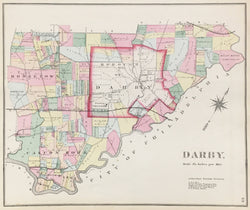
H.W. Hopkins. "Darby.” From Atlas of Delaware County.
Philadelphia: H. W. Hopkins, 1870. 16 x 13 1/4. Lithograph. Original hand color. Very good condition.
Starting around 1870, atlases of properties within and outside of Philadelphia began to be published by such firms as Bromley, Hopkins and Mueller. Their output has provided us with excellent, detailed images of the growth of the city of Philadelphia and the suburbs as well from the 1870s through the first part of the twentieth century. These atlases were used for planning, government purposes, and just for the information of citizens of the area. These atlases are also known as 'railroad, real estate, and/or insurance' atlases and contained very accurate and detailed information such as streets, properties, parks, and other topographical and social features.
We have many maps from the following areas: The City of Philadelphia; Montgomery County and townships; Delaware County and townships; Chester County and townships; Bucks County and townships.
 %20%0A%20%0Ahttps://philaprintshop.com/products/hopkins-h-w-darby-1870 %20%0A%20%0AHopkins,%20H.W.%20%22Darby%22 %20%0A%20%0A//philaprintshop.com/cdn/shop/products/hopkinsdarbyc_1024x1024.jpg?v=1657383609 %20%0A%20%0AAntique Prints, Maps, Drawings, Paintings and Rare Books! %20%0A%20%0AThe Philadelphia Print Shop %20%0A106 E. Lancaster Avenue, Lower Level %20%0AWayne, PA 19087 %20%0A%20%0APhilaPrintShop.com %20%0A@PhiladelphiaPrintShop %20%0A 610 (808) 6165)