![Rand McNally [Texas] and [Oklahoma & Indian Territory]](http://philaprintshop.com/cdn/shop/products/rand05txokc_{width}x.jpg?v=1670437009)
![Rand McNally [Texas] and [Oklahoma & Indian Territory]](http://philaprintshop.com/cdn/shop/products/rand05oktxc_{width}x.jpg?v=1670437013)
![Rand McNally [Texas] and [Oklahoma & Indian Territory]](http://philaprintshop.com/cdn/shop/products/rand05oktx_{width}x.jpg?v=1670437017)
![Rand McNally [Texas] and [Oklahoma & Indian Territory]](http://philaprintshop.com/cdn/shop/products/rand05txok_{width}x.jpg?v=1670437023)
![Rand McNally [Texas] and [Oklahoma & Indian Territory]](http://philaprintshop.com/cdn/shop/products/rand05txokc_530x@2x.jpg?v=1670437009)
![Load image into Gallery viewer, Rand McNally [Texas] and [Oklahoma & Indian Territory]](http://philaprintshop.com/cdn/shop/products/rand05txokc_1024x1024@2x.jpg?v=1670437009)
![Load image into Gallery viewer, Rand McNally [Texas] and [Oklahoma & Indian Territory]](http://philaprintshop.com/cdn/shop/products/rand05oktxc_1024x1024@2x.jpg?v=1670437013)
![Load image into Gallery viewer, Rand McNally [Texas] and [Oklahoma & Indian Territory]](http://philaprintshop.com/cdn/shop/products/rand05oktx_1024x1024@2x.jpg?v=1670437017)
![Load image into Gallery viewer, Rand McNally [Texas] and [Oklahoma & Indian Territory]](http://philaprintshop.com/cdn/shop/products/rand05txok_1024x1024@2x.jpg?v=1670437023)
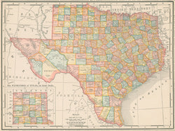
[Oklahoma and Indian Territory.] & on verso [Texas] From New General Atlas of the World.
Chicago: Rand, McNally & Co., 1905. 9 x 11 3/8. Cerograph, with full original color. Very good condition.
A map showing the last configuration of the American Indian Territory and on the verso, a map of Texas.
The original Indian Territory west of the Mississippi encompassed most of the Louisiana Purchase, not including Missouri, Arkansas and Louisiana. With the Kansas-Nebraska Act of 1854, the Indian Territory was shrunk to just that part of the purchase south of the 37th parallel (the southern Kansas border), that is, today's Oklahoma (created as a state just about a decade later). After the Civil War, the western part of this territory was taken back from the Indians and in 1890 became the Oklahoma Territory. This map shows that configuration, with the Oklahoma Territory in the west and the final, small Indian Territory in the east. Realizing they might be legislated out of existence, the citizens of the Indian Territory applied to statehood (as the state of Sequoyah) in 1905, but Congress instead turned the entire area shown here into the state of Oklahoma in 1907.
 %20%0A%20%0Ahttps://philaprintshop.com/products/rand-mcnally-texas-and-oklahoma-indian-territory %20%0A%20%0ARand%20McNally%20[Texas]%20and%20[Oklahoma%20%26%20Indian%20Territory] %20%0A%20%0A//philaprintshop.com/cdn/shop/products/rand05txokc_1024x1024.jpg?v=1670437009 %20%0A%20%0AAntique Prints, Maps, Drawings, Paintings and Rare Books! %20%0A%20%0AThe Philadelphia Print Shop %20%0A106 E. Lancaster Avenue, Lower Level %20%0AWayne, PA 19087 %20%0A%20%0APhilaPrintShop.com %20%0A@PhiladelphiaPrintShop %20%0A 610 (808) 6165)