![Tanner, Henry S. “Holland and Belgium.” [Netherlands] 1847](http://philaprintshop.com/cdn/shop/products/mitchell-netherlandsc_{width}x.jpg?v=1677607819)
![Tanner, Henry S. “Holland and Belgium.” [Netherlands] 1847](http://philaprintshop.com/cdn/shop/products/mitchell-netherlands_{width}x.jpg?v=1677607823)
![Tanner, Henry S. “Holland and Belgium.” [Netherlands] 1847](http://philaprintshop.com/cdn/shop/products/mitchell-netherlandsc_530x@2x.jpg?v=1677607819)
![Load image into Gallery viewer, Tanner, Henry S. “Holland and Belgium.” [Netherlands] 1847](http://philaprintshop.com/cdn/shop/products/mitchell-netherlandsc_1024x1024@2x.jpg?v=1677607819)
![Load image into Gallery viewer, Tanner, Henry S. “Holland and Belgium.” [Netherlands] 1847](http://philaprintshop.com/cdn/shop/products/mitchell-netherlands_1024x1024@2x.jpg?v=1677607823)
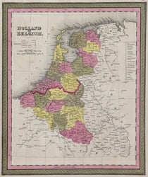
Henry S. Tanner (1831-1918). “Holland and Belgium.” [Netherlands]. From New Universal Atlas.
Philadelphia: S.A. Mitchell, Sr., ca. 1847. 12 ¾ and 10 ¾ (neat lines). Lithographic transfer from copper engraving. Original hand color. Minor spotting in map. Very good condition.
A crisp, detailed map by the great American cartographer, Henry Schenck Tanner and published by Samuel Augustus Mitchell, Sr., one the leading cartographic publisher of the period. Beginning in 1819, Tanner published his American Atlas, which was a huge success. This inspired Tanner to produce his Universal Atlas, of more manageable size, which contained fine maps of each state and a number of cities. These maps were purchased by S. Augustus Mitchell and reissued in his editions of Tanner’s atlas. Mitchell was born in Connecticut where he engaged in teaching. Upon the discovery that geography texts were inadequate, he wrote his own and in 1829-30 moved to Philadelphia, then the leading publishing center in the United States. He acquired the stock and plates of Anthony Finley’s publishing company and improved on those copper plate maps. In 1846, with the issuing of his New Universal Atlas, Mitchell began using the new technique of stone lithography.
 %20%0A%20%0Ahttps://philaprintshop.com/products/tanner-henry-s-holland-and-belgium-netherlands %20%0A%20%0ATanner,%20Henry%20S.%20%E2%80%9CHolland%20and%20Belgium.%E2%80%9D%20%20[Netherlands]%201847 %20%0A%20%0A//philaprintshop.com/cdn/shop/products/mitchell-netherlandsc_1024x1024.jpg?v=1677607819 %20%0A%20%0AAntique Prints, Maps, Drawings, Paintings and Rare Books! %20%0A%20%0AThe Philadelphia Print Shop %20%0A106 E. Lancaster Avenue, Lower Level %20%0AWayne, PA 19087 %20%0A%20%0APhilaPrintShop.com %20%0A@PhiladelphiaPrintShop %20%0A 610 (808) 6165)