

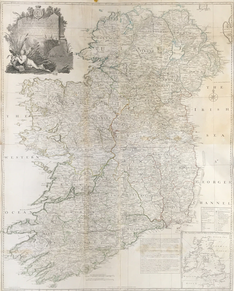


John Rocque. “A Map of the Kingdom of Ireland, Divided into Provinces Counties and Baronies, Shewing The Archbishopricks, Bishopricks, Cities, Boroughs, Market Towns, Villages, Barracks, Mountains, Lakes, Bogs, Rivers, Bridges, Ferries, Passes…”
London: Laurie & Whittle, 12th May, 1794. 48 1/2 x 38. Four sheets joined as one map. Engraving. Original outline color. Good margins. Some faint browning in map as to be expected. Map has been professionally conserved. Else, very good condition for a map of this size.
One of the largest maps ever produced of Ireland, this stunning cartographic document provides an amazing amount of information on the Emerald Isle, an impressive listing of which is contained in the title. The map was drawn by John (or Jean) Rocque, a Huguenot surveyor and engraver who worked in London from 1734 to 1762. The large size and precise engraving make this map easy to read and a font of information. An elaborately etched title cartouche appears in the top left corner, showing a water nymph lying by a stream, in which a pair of cattle stand. There are also two inset tables and an inset map of The Sea Coasts of Great Britain and Ireland. A wonderful eighteenth century Irish artifact.
 %20%0A%20%0Ahttps://philaprintshop.com/products/rocque-john-a-map-of-the-kingdom-of-ireland-divided-into-provinces-counties-and-baronies-shewing-the-archbishopricks-bishopricks-cities-boroughs-market-towns-villages-barracks-mountains-lakes-bogs-rivers-bridges-ferries-passes %20%0A%20%0ARocque,%20John%20%20%E2%80%9CA%20Map%20of%20the%20Kingdom%20of%20Ireland,%20Divided%20into%20Provinces%20Counties%20and%20Baronies,%E2%80%A6%E2%80%9D %20%0A%20%0A//philaprintshop.com/cdn/shop/products/rocqueirelandc_1024x1024.jpg?v=1642712797 %20%0A%20%0AAntique Prints, Maps, Drawings, Paintings and Rare Books! %20%0A%20%0AThe Philadelphia Print Shop %20%0A106 E. Lancaster Avenue, Lower Level %20%0AWayne, PA 19087 %20%0A%20%0APhilaPrintShop.com %20%0A@PhiladelphiaPrintShop %20%0A 610 (808) 6165)