


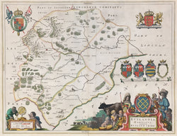
Joan Blaeu. "Rutlandia Comitatus: Rutlandshire."
Amsterdam: J. Blaeu, ca. 1645. 15 x 19 ½ (neat lines). Engraving. Full original 17th century hand coloring. Full margins. Latin text on verso. Minor separation at bottom along center fold just into map. Else, very good condition.
Rutland is a ceremonial county and unitary authority in the East Midlands, England. The county is bounded to the west and north by Leicestershire, to the northeast by Lincolnshire and the southeast by Northamptonshire.
The maps issued by the Blaeu firm are known for their fine engraving, coloring and design, and have been called "the highest expression of Dutch cartographic art." This beautiful map of Rutland issued by the firm are typical of their work, with clear topographical information as well as profuse decorative elements. These include coats-of-arms and heraldic shields of various local noblemen and delightfully illustrated title cartouches.
 %20%0A%20%0Ahttps://philaprintshop.com/products/blaeu-joan-rutlandia-comitatus-rutlandshire %20%0A%20%0ABlaeu,%20Joan%20%22Rutlandia%20Comitatus:%20Rutlandshire%22 %20%0A%20%0A//philaprintshop.com/cdn/shop/products/blaeurutlandc_1024x1024.jpg?v=1663268471 %20%0A%20%0AAntique Prints, Maps, Drawings, Paintings and Rare Books! %20%0A%20%0AThe Philadelphia Print Shop %20%0A106 E. Lancaster Avenue, Lower Level %20%0AWayne, PA 19087 %20%0A%20%0APhilaPrintShop.com %20%0A@PhiladelphiaPrintShop %20%0A 610 (808) 6165)