![Unattributed “Falmouth, Neck 1775. As it was when destroyed by Mowett. Oct. 18, 1775” [Portland, Maine]](http://philaprintshop.com/cdn/shop/files/falmouthneckthmb_{width}x.jpg?v=1704297413)
![Unattributed “Falmouth, Neck 1775. As it was when destroyed by Mowett. Oct. 18, 1775” [Portland, Maine]](http://philaprintshop.com/cdn/shop/files/falmouthneck_{width}x.jpg?v=1704297413)
![Unattributed “Falmouth, Neck 1775. As it was when destroyed by Mowett. Oct. 18, 1775” [Portland, Maine]](http://philaprintshop.com/cdn/shop/files/falmouthneckthmb_530x@2x.jpg?v=1704297413)
![Load image into Gallery viewer, Unattributed “Falmouth, Neck 1775. As it was when destroyed by Mowett. Oct. 18, 1775” [Portland, Maine]](http://philaprintshop.com/cdn/shop/files/falmouthneckthmb_1024x1024@2x.jpg?v=1704297413)
![Load image into Gallery viewer, Unattributed “Falmouth, Neck 1775. As it was when destroyed by Mowett. Oct. 18, 1775” [Portland, Maine]](http://philaprintshop.com/cdn/shop/files/falmouthneck_1024x1024@2x.jpg?v=1704297413)
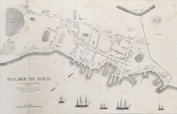
Unattributed. “Falmouth, Neck 1775. As it was when destroyed by Mowett. Oct. 18, 1775” [Portland, Maine].
From Willis’ History of Portland. Portland: William Willis, 1831. 16 ¼ x 24 5/8 (neat lines). Lithograph by Pendleton on thin tissue paper. With folds as originally issued with some minor creases as to be expected. Scattered foxing with a few scattered pin holes. Old repaired tear in left hand margin. Else, good condition. A/A
This 19th century map shows Falmouth Neck, (Portland) Maine just before it was burned by the British in October 1775. This was the governmental and commercial center of Ancient Falmouth. Many early families’ homes and business are indicated in the map. Cape Elizabeth and South Portland, became a separate town in 1765.
 %20%0A%20%0Ahttps://philaprintshop.com/products/unattributed-falmouth-neck-1775-as-it-was-when-destroyed-by-mowett-oct-18-1775-portland-maine %20%0A%20%0AUnattributed%20%E2%80%9CFalmouth,%20Neck%201775.%20%20As%20it%20was%20when%20destroyed%20by%20Mowett.%20Oct.%2018,%201775%E2%80%9D%20%20[Portland,%20Maine] %20%0A%20%0A//philaprintshop.com/cdn/shop/files/falmouthneckthmb_1024x1024.jpg?v=1704297413 %20%0A%20%0AAntique Prints, Maps, Drawings, Paintings and Rare Books! %20%0A%20%0AThe Philadelphia Print Shop %20%0A106 E. Lancaster Avenue, Lower Level %20%0AWayne, PA 19087 %20%0A%20%0APhilaPrintShop.com %20%0A@PhiladelphiaPrintShop %20%0A 610 (808) 6165)