![Bradford, Thomas G. [Plan of the Principal Cities in the United States]](http://philaprintshop.com/cdn/shop/files/bradforduscitiesthmb_{width}x.jpg?v=1719602351)
![Bradford, Thomas G. [Plan of the Principal Cities in the United States]](http://philaprintshop.com/cdn/shop/files/bradforduscities_{width}x.jpg?v=1719602361)
![Bradford, Thomas G. [Plan of the Principal Cities in the United States]](http://philaprintshop.com/cdn/shop/files/bradforduscitiesthmb_530x@2x.jpg?v=1719602351)
![Load image into Gallery viewer, Bradford, Thomas G. [Plan of the Principal Cities in the United States]](http://philaprintshop.com/cdn/shop/files/bradforduscitiesthmb_1024x1024@2x.jpg?v=1719602351)
![Load image into Gallery viewer, Bradford, Thomas G. [Plan of the Principal Cities in the United States]](http://philaprintshop.com/cdn/shop/files/bradforduscities_1024x1024@2x.jpg?v=1719602361)
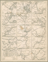
Thomas G. Bradford. [Plan of the Principal Cities in the United States]. From A Comprehensive Atlas. Geographical, Historical & Commercial. Boston: William D. Ticknor, 1835. 7 5/8 x 10. Engraving. Light original hand color in border. Repaired three inch tear into map upper right hand side. Light stain in map of Charleston. Top and bottom right hand margin corners chipped. Else, good condition.
Cities depicted are: Portland, ME, Boston, Providence, New York, Albany, Baltimore, Philadelphia, Charleston, Savannah, New Orleans, St. Louis, Louisville, Nashville, Niagara Falls, & Cincinnati.
A composite map from Boston publisher and cartographer, Thomas G. Bradford. Originally issued in 1835, Bradford’s Comprehensive Atlas contained maps of the different United States and other parts of the world, based on the most up-to-date information available at the time.
 %20%0A%20%0Ahttps://philaprintshop.com/products/bradford-thomas-g-plan-of-the-principal-cities-in-the-united-states %20%0A%20%0ABradford,%20Thomas%20G.%20%20[Plan%20of%20the%20Principal%20Cities%20in%20the%20United%20States] %20%0A%20%0A//philaprintshop.com/cdn/shop/files/bradforduscitiesthmb_1024x1024.jpg?v=1719602351 %20%0A%20%0AAntique Prints, Maps, Drawings, Paintings and Rare Books! %20%0A%20%0AThe Philadelphia Print Shop %20%0A106 E. Lancaster Avenue, Lower Level %20%0AWayne, PA 19087 %20%0A%20%0APhilaPrintShop.com %20%0A@PhiladelphiaPrintShop %20%0A 610 (808) 6165)