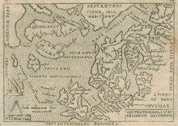
Giovanni Botero (c.1544-1617). “Europa. Scandia.” [Scandinavia, Britain, Iceland, Frisland, Greenland, New Foundland]. From G. Botero’s Relationi Universali.
Venice: I. Giunti, ca. 1645. 8 ¼ x 5 ¾ (paper). Copper engraving. Strong impression. Some staining right hand side just into map. Else, very good condition.
An interesting map of Northern Europe with the North Atlantic islands of Greenland and Iceland. This map was issued in Giovanni Botero’s popular work on the nations of the world. The map is a re-engraving of a plate which first appeared in 1582. It went through a number of modifications, including the unusual engraved line which circles the continents on this plate, though the basic geography reflects the original rendering after Abraham Ortelius. This is a fascinating map from the seventeenth century and a lovely Italian engraving.

![Botero, Giovanni "Europa. Scandia.” [Scandinavia, Britain, Iceland, Frisland, Greenland, New Foundland]](http://philaprintshop.com/cdn/shop/products/botero-europec_{width}x.jpg?v=1678910252)
![Botero, Giovanni "Europa. Scandia.” [Scandinavia, Britain, Iceland, Frisland, Greenland, New Foundland]](http://philaprintshop.com/cdn/shop/products/botero-europe_{width}x.jpg?v=1678910256)
![Load image into Gallery viewer, Botero, Giovanni "Europa. Scandia.” [Scandinavia, Britain, Iceland, Frisland, Greenland, New Foundland]](http://philaprintshop.com/cdn/shop/products/botero-europec_110x110@2x.jpg?v=1678910252)
![Load image into Gallery viewer, Botero, Giovanni "Europa. Scandia.” [Scandinavia, Britain, Iceland, Frisland, Greenland, New Foundland]](http://philaprintshop.com/cdn/shop/products/botero-europe_110x110@2x.jpg?v=1678910256)
