
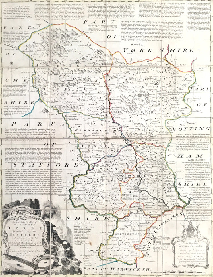
Emanuel Bowen. "An Accurate Map of the County of Derby...."
London: R. Sayer, and J. & C. Bowles, 1765. Dissected into 16 sections, mounted on linen and folded into original paper covers. 27 1/4 x 21 1/8. Engraving by E. Bowen. Original outline color. Very good condition.
A large, highly detailed and unusual folding map of Derbyshire. This map is by Emanuel Bowen, one of the best known cartographers of the eighteenth century. Bowen, together with the equally famous Thomas Kitchin, began to publish a series of large county maps in 1749, culminating in their Large English Atlas, which was issued in on-going editions from 1750 to 1794. These maps are very popular both for their large size and for the wealth of information included on their printed surface. This map of Derbyshire is typical of their detailed maps, with hills, roads, towns, villages, cities, country estates, churches, and much else is clearly presented. The hundreds are outlined in contrasting colors and there are a number of paragraphs dotted about the map describing major towns, a list of the seats of the local nobility, and text about the wonders of the county. An elaborate rococo title cartouche graces the bottom left corner, and a smaller dedication cartouche is in the lower right.
What makes this map unusual is that it is a separately issued, folding map. The map, which also appeared in the Large English Atlas, was cut into 16 sections, which were mounted on linen so that they folded into a small, ca. 6 1/2 x 5 1/2, size, which then was inserted into a paper envelope. Maps such as this would be easier to handle, store, and perhaps use when one was traveling. Maps such as this, however, are also scarcer as they have a much lower survival rate than atlas maps. This is a most impressive and unusual map of Derbyshire.
 %20%0A%20%0Ahttps://philaprintshop.com/products/bowen-emanuel-an-accurate-map-of-the-county-of-derby %20%0A%20%0ABowen,%20Emanuel%20%22An%20Accurate%20Map%20of%20the%20County%20of%20Derby....%22 %20%0A%20%0A//philaprintshop.com/cdn/shop/products/bowenderbyfold_1024x1024.jpg?v=1614249649 %20%0A%20%0AAntique Prints, Maps, Drawings, Paintings and Rare Books! %20%0A%20%0AThe Philadelphia Print Shop %20%0A106 E. Lancaster Avenue, Lower Level %20%0AWayne, PA 19087 %20%0A%20%0APhilaPrintShop.com %20%0A@PhiladelphiaPrintShop %20%0A 610 (808) 6165)