

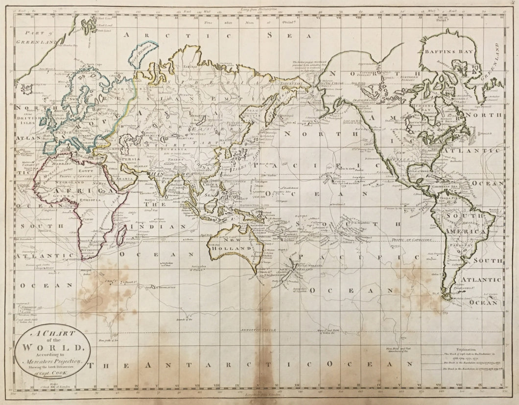


Mathew Carey. “Chart of the World According to Mercators Projection shown the latest Discoveries of Capt. Cook.”
Philadelphia: M. Carey, 1814. 14 1/4 x 18 ¾. Engraving. Original outline hand color. Staining in map. Else, fine condition. As is.
A nice example of a map of the world with the voyages of Captain James Cook indicated by differing lines. This map is very similar to the one issued in Guthrie's Geography, and is one of earliest folio maps of the world printed in America. The map was published by Mathew Carey in 1814, and was from his General Atlas which represented the best American cartographic work of the period.
In England, William Guthrie's geographies were disparaging to the former colonies, so Carey wrote new text and produced his own maps for an "improved" edition that merely recognized while not compensating Guthrie. As a youth Carey had been expelled from Ireland for printing seditious literature, so he escaped to Paris where he worked for Benjamin Franklin until the cessation of hostilities. He then went to Philadelphia, worked for Franklin briefly and later opened his own printing shop. Eventually Mathew Carey became one of the great citizens of Philadelphia and founder of the present-day firm of Lea & Febiger, which until recently was located on Washington Square.
Carey, an Irish immigrant, established the first American specialized cartographic publishing firm. He set up an elaborate cottage system of craftsmen for engraving, printing, and coloring his maps utilizing the best independent artists directed to a common end. Carey is important, then, not only for the excellent maps he produced, but for his setting the pattern for American map publishing, to be followed by the likes of John Melish and Henry S. Tanner. This map is a fine example of his output.
 %20%0A%20%0Ahttps://philaprintshop.com/products/carey-chart-of-the-world-according-to-mercators-projection-shown-the-latest-discoveries-of-capt-cook %20%0A%20%0ACarey.%20%20%E2%80%9CChart%20of%20the%20World%20According%20to%20Mercators%20Projection%20shown%20the%20latest%20Discoveries%20of%20Capt.%20Cook.%E2%80%9D %20%0A%20%0A//philaprintshop.com/cdn/shop/products/careyworldc_1024x1024.jpg?v=1632934037 %20%0A%20%0AAntique Prints, Maps, Drawings, Paintings and Rare Books! %20%0A%20%0AThe Philadelphia Print Shop %20%0A106 E. Lancaster Avenue, Lower Level %20%0AWayne, PA 19087 %20%0A%20%0APhilaPrintShop.com %20%0A@PhiladelphiaPrintShop %20%0A 610 (808) 6165)