![Powell, J.W. "10th. Annual Report United States Geological Survey. 1888-89. Part I. Geology. [and] Part II. Irrigation"](http://philaprintshop.com/cdn/shop/products/usgs1888-89b_{width}x.jpg?v=1659539934)
![Powell, J.W. "10th. Annual Report United States Geological Survey. 1888-89. Part I. Geology. [and] Part II. Irrigation"](http://philaprintshop.com/cdn/shop/products/usgs1888-89_{width}x.jpg?v=1659539934)
![Powell, J.W. "10th. Annual Report United States Geological Survey. 1888-89. Part I. Geology. [and] Part II. Irrigation"](http://philaprintshop.com/cdn/shop/products/usgs1888-89a_{width}x.jpg?v=1659539934)
![Powell, J.W. "10th. Annual Report United States Geological Survey. 1888-89. Part I. Geology. [and] Part II. Irrigation"](http://philaprintshop.com/cdn/shop/products/usgs1888-89c_{width}x.jpg?v=1659539926)
![Powell, J.W. "10th. Annual Report United States Geological Survey. 1888-89. Part I. Geology. [and] Part II. Irrigation"](http://philaprintshop.com/cdn/shop/products/usgs1888-89d_{width}x.jpg?v=1659539930)

![Load image into Gallery viewer, Powell, J.W. "10th. Annual Report United States Geological Survey. 1888-89. Part I. Geology. [and] Part II. Irrigation"](http://philaprintshop.com/cdn/shop/products/usgs1888-89b_1024x1024@2x.jpg?v=1659539934)
![Load image into Gallery viewer, Powell, J.W. "10th. Annual Report United States Geological Survey. 1888-89. Part I. Geology. [and] Part II. Irrigation"](http://philaprintshop.com/cdn/shop/products/usgs1888-89_1024x1024@2x.jpg?v=1659539934)
![Load image into Gallery viewer, Powell, J.W. "10th. Annual Report United States Geological Survey. 1888-89. Part I. Geology. [and] Part II. Irrigation"](http://philaprintshop.com/cdn/shop/products/usgs1888-89a_1024x1024@2x.jpg?v=1659539934)
![Load image into Gallery viewer, Powell, J.W. "10th. Annual Report United States Geological Survey. 1888-89. Part I. Geology. [and] Part II. Irrigation"](http://philaprintshop.com/cdn/shop/products/usgs1888-89c_1024x1024@2x.jpg?v=1659539926)
![Load image into Gallery viewer, Powell, J.W. "10th. Annual Report United States Geological Survey. 1888-89. Part I. Geology. [and] Part II. Irrigation"](http://philaprintshop.com/cdn/shop/products/usgs1888-89d_1024x1024@2x.jpg?v=1659539930)
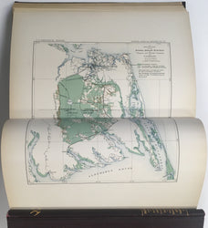
J. W. Powell. 10th. Annual Report United States Geological Survey. 1888-89. Part I. Geology. [and] Part II. Irrigation.
Washington: 1890. I: 98 plates and 69 figures. 774 pages. In back pocket is map of U.S. showing progress of the topographic surveys to 1888-89. Accompanying papers are Shaler on Dismal Swamp of Virginia and North Carolina, Penokee Iron Bearing Region of Michigan and Wisconsin by Duer and Van Hise, and Fauna of the Lower Cambrian by Walcott. II: 123 pages. Maps excellent. (2 vols.).
This group has loose or broken hinges (except as noted) on all the bindings, which is normal for these large volumes. They are superior copies because all the maps in the back pockets are present and are not brittle or cracked as is so often the case. These maps are usable (with care) and are lovely examples of American cartography.
 %20%0A%20%0Ahttps://philaprintshop.com/products/powell-j-w-10th-annual-report-united-states-geological-survey-1888-89-part-i-geology-and-part-ii-irrigation %20%0A%20%0APowell,%20J.W.%20%20%2210th.%20Annual%20Report%20United%20States%20Geological%20Survey.%20%201888-89.%20%20Part%20I.%20Geology.%20[and]%20Part%20II.%20Irrigation%22 %20%0A%20%0A//philaprintshop.com/cdn/shop/products/usgs1888-89b_1024x1024.jpg?v=1659539934 %20%0A%20%0AAntique Prints, Maps, Drawings, Paintings and Rare Books! %20%0A%20%0AThe Philadelphia Print Shop %20%0A106 E. Lancaster Avenue, Lower Level %20%0AWayne, PA 19087 %20%0A%20%0APhilaPrintShop.com %20%0A@PhiladelphiaPrintShop %20%0A 610 (808) 6165)