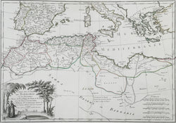
Rigobert Bonne. "Carte des Cotes de Barbarie ou les Royaumes de Maroc, de Fez, d'Alger, de Tunis, et de Tripoli . . ."
From Atlas Moderne. Paris: Jean Lattré & J. Thomas, 1762. 12 x 17 1/2. Engraving. Original outline color. Very good condition.
Rigobert Bonne was the Royal Hydrographer of France, but he produced many fine topographical and historical maps as well as charts. This map combined both some up-to-date topographical rendering with the historical detail of this region. Population centers are connected by rivers with much detail devoted to the interior. Of interest is the information also on the European kingdoms of Spain, Portugal, Italy, Greece and the many islands of the Mediterranean. A handsome, finely etched title cartouche includes two turbanned men who discuss an oasis at bottom left.

![Bonne, Rigobert "Carte des Cotes de Barbarie ou les Royaumes de Maroc, de Fez, d'Alger, de Tunis, et de Tripoli..." [North Africa]. . .."](http://philaprintshop.com/cdn/shop/files/bonnenafricathmb_{width}x.jpg?v=1705087501)
![Bonne, Rigobert "Carte des Cotes de Barbarie ou les Royaumes de Maroc, de Fez, d'Alger, de Tunis, et de Tripoli..." [North Africa]. . .."](http://philaprintshop.com/cdn/shop/files/bonnenafrica_{width}x.jpg?v=1705087501)
![Load image into Gallery viewer, Bonne, Rigobert "Carte des Cotes de Barbarie ou les Royaumes de Maroc, de Fez, d'Alger, de Tunis, et de Tripoli..." [North Africa]. . .."](http://philaprintshop.com/cdn/shop/files/bonnenafricathmb_110x110@2x.jpg?v=1705087501)
![Load image into Gallery viewer, Bonne, Rigobert "Carte des Cotes de Barbarie ou les Royaumes de Maroc, de Fez, d'Alger, de Tunis, et de Tripoli..." [North Africa]. . .."](http://philaprintshop.com/cdn/shop/files/bonnenafrica_110x110@2x.jpg?v=1705087501)
