


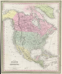
"Map of North America."
Philadelphia: Thomas, Cowperthwait & Co., 1855. 15 1/2 x 12 7/8. Lithographic transfer from engraved plate. Original hand-coloring. Narrow margin at left due to original binding, else very good condition.
A strong and beautifully crafted map from the mid-nineteenth century, published by Thomas, Cowperthwait & Co. This firm took over the publication of S. Augustus Mitchell's important Universal Atlas in 1850, and they continued to produce up-dated maps that were amongst the best issued in the period. This map issued early in 1855, for instance, is one of the first to show the Nebraska and Kansas Territories that had been formed from the Missouri Territory and some of the Indian Territory in May, 1854. The map has a striking appearance, with warm hand coloring that well complements the clear presentation. For its fascinating detail and decorative appeal, this is an excellent view of the period.
 %20%0A%20%0Ahttps://philaprintshop.com/products/thomas-cowperthwait-co-map-of-north-america %20%0A%20%0AThomas,%20Cowperthwait%20%26%20Co.%20%22Map%20of%20North%20America%22 %20%0A%20%0A//philaprintshop.com/cdn/shop/products/cowperthwaitnamericac_1024x1024.jpg?v=1651681752 %20%0A%20%0AAntique Prints, Maps, Drawings, Paintings and Rare Books! %20%0A%20%0AThe Philadelphia Print Shop %20%0A106 E. Lancaster Avenue, Lower Level %20%0AWayne, PA 19087 %20%0A%20%0APhilaPrintShop.com %20%0A@PhiladelphiaPrintShop %20%0A 610 (808) 6165)