


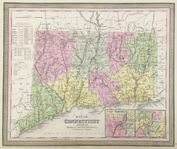
S. Augustus Mitchell. Plate 9. “Map of Connecticut."
Philadelphia: Thomas, Cowperthwait & Co., 1851. 12 1/4 x 14 3/4. Lithographic transfer from engraved plate. Full original color. Paper time toned. Very good condition.
A strong and beautifully crafted map of Connecticut from the mid-nineteenth century, published by Thomas, Cowperthwait & Co.. This firm took over the publication of S. Augustus Mitchell's important Universal Atlas in 1850, and they continued to produce up-dated maps that were amongst the best issued in the period. The map is filled with myriad topographical details, including rivers, towns, lakes and political borders. The Thomas, Cowperthwait & Co. maps are especially known for their depiction of the transportation routes of the states, and this map is no exception. The transportation infrastructure was extremely important at this period of increased immigration and travel. This information is clearly depicted here, including rail lines, steamboat routes, canals and roads. Two inset maps are included, of Hartford and New Haven.
 %20%0A%20%0Ahttps://philaprintshop.com/products/mitchell-s-augustus-map-of-connecticut %20%0A%20%0AMitchell,%20S.%20Augustus%20%20%E2%80%9CMap%20of%20Connecticut.%22 %20%0A%20%0A//philaprintshop.com/cdn/shop/products/cowperthwaitct1851c_1024x1024.jpg?v=1639518708 %20%0A%20%0AAntique Prints, Maps, Drawings, Paintings and Rare Books! %20%0A%20%0AThe Philadelphia Print Shop %20%0A106 E. Lancaster Avenue, Lower Level %20%0AWayne, PA 19087 %20%0A%20%0APhilaPrintShop.com %20%0A@PhiladelphiaPrintShop %20%0A 610 (808) 6165)