


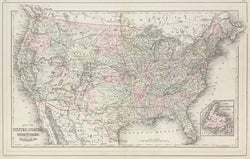
“Map of the United States, and Territories. Together with Canada &c.” From Mitchell’s New General Atlas.
Philadelphia: W.M. Bradley & Bro., 1886. 13 1/2 x 21 1/2. Lithograph. Original hand color. Very good condition.
A precisely detailed map from the Philadelphia publishing firm of William M. Bradley & Bro. Bradley took over the publication of Mitchell’s New General Atlas in the early 1880s and this is a fine example of nineteenth century American mapmaking. It shows the United States with impressive detail, with emphasis on rivers, towns, and the myriad railroad lines criss-crossing the states. States and territories are named and delineated in attractive pastel colors.
 %20%0A%20%0Ahttps://philaprintshop.com/products/bradley-w-m-map-of-the-united-states %20%0A%20%0ABradley,%20W.M.%20%22Map%20of%20the%20United%20States,%20and%20Territories.%20Together%20with%20Canada%20%26c.%22 %20%0A%20%0A//philaprintshop.com/cdn/shop/products/brqadley86usc_1024x1024.jpg?v=1640896316 %20%0A%20%0AAntique Prints, Maps, Drawings, Paintings and Rare Books! %20%0A%20%0AThe Philadelphia Print Shop %20%0A106 E. Lancaster Avenue, Lower Level %20%0AWayne, PA 19087 %20%0A%20%0APhilaPrintShop.com %20%0A@PhiladelphiaPrintShop %20%0A 610 (808) 6165)