
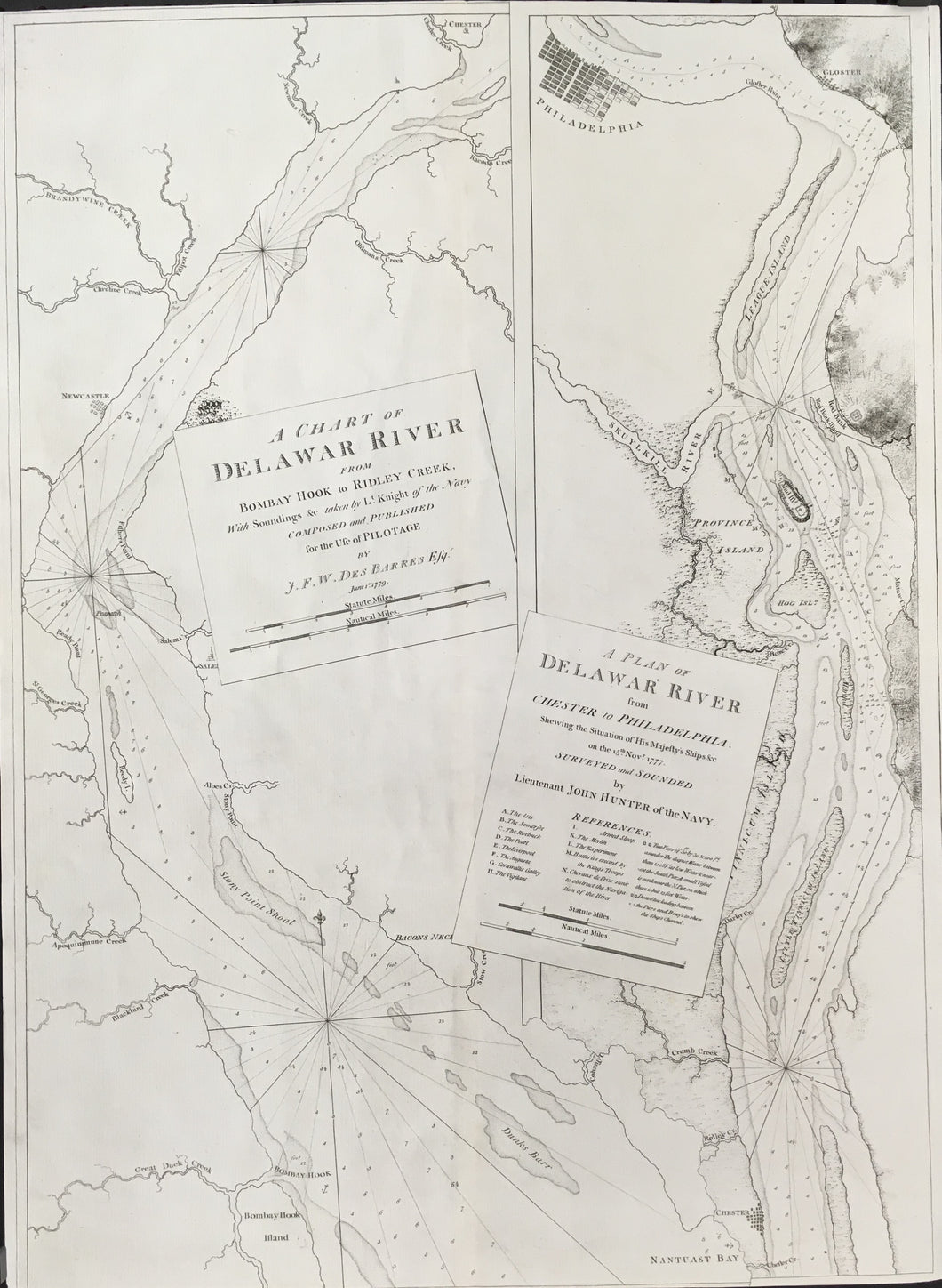
After Lieutenants Knight & John Hunter (Royal Navy). “A Chart of Delaware River from Bombay Hook to Ridley Creek, with soundings &c. taken by Lt. Knight of the Navy . . .” with a second panel entitled “A Plan of Delawar [sic] River from Chester to Philadelphia. Shewing the Situation of His Majesty’s Ships &c on the 15th. Novr. 1777.” London: The Atlantic Neptune, 1780. 30 ¼ x 22 3/8 (paper). Full sheet. Etching on heavy laid paper. Vertical center fold as issued. Watermarked LVG with a fleur-de-lye surrounded by a coronet with Roman numeral IV. Two faint horizontal printer’s wrinkles middle of map left hand side. Else, very good condition. Nebenzahl, 136; Sellers & VanEa, 1370; National Maritime Museum Cat.: 320: 130-31; Snyder, 85. Scarce. $7,500
After the French & Indian War, the British began the project of mapping their vast, newly acquired lands in North America. As the unpleasantness leading up to the American Revolution began, this surveying was given new priority. The job of coordinating and publishing the surveys fell upon J.F.W. DesBarres, who had commanded the mapping of the coasts of present-day eastern Canada. The resulting atlas, The Atlantic Neptune, was called by A.P. Loring, “the first great marine atlas of the eastern seaboard.” Loring quotes Obadiah Rich who called it, “the most splendid collection of charts, plans and views ever published.” [“The Atlantic Neptune” in American Maritime Prints ed. E.W. Hall (New Bedford, 1985): 1-40]. This is an excellent example of the maps from this important atlas.
This two panel chart of Delaware River shows the river from Philadelphia south to Bombay Hook, Delaware. As stated on the chart, it was “Composed and Published for the use of Pilotage by J.F. W. DesBarres Esqr,” so the focus of detail is on the nature of the river itself. The coastline, mouths of creeks, shoals and sand bars, and soundings are shown with careful precision, and rhumb lines are used to help with navigation of a ship up this relatively narrow river. Inland information is sparse because it is limited to that which was visible by sight from navigable waters. An occasional higher elevation is shown and basic town plans for New Castle, Chester, and Philadelphia are present. Conventional symbols for swamps and waterways are shown for as much as a few miles inland in places.
This map is considered scarce because there were relatively fewer maps of the coast as work progressed from north to south. DesBarres had done such painstaking work on the Maritime Provinces, and most early surveying during the war was in the northern waters. The war in the middle colonies was more a land war than a sea theater, so the focus was on land maps rather than sea charts. Also, this utilitarian chart had to be off the presses and sent immediately to the army and navy that was concurrently occupying Philadelphia and vicinity.

 %20%0A%20%0Ahttps://philaprintshop.com/products/joseph-frederick-wallet-desbarres-a-chart-of-delawar-sic-river-from-bombay-hook-to-ridley-creek-and-a-plan-of-delawar-sic-river-from-chester-to-philadelphia %20%0A%20%0ADesBarres,%20Joseph%20Frederick%20Wallet%20%22A%20Chart%20of%20Delawar%20(sic)%20River%20from%20Bombay%20Hook%20to%20Ridley%20Creek.%E2%80%9D%20and%20%E2%80%9CA%20Plan%20of%20Delawar%20(sic)%20River%20from%20Chester%20to%20Philadelphia%E2%80%A6%E2%80%9D %20%0A%20%0A//philaprintshop.com/cdn/shop/files/desbarresdelaware_829e1fc3-bd1b-4890-9f26-962b9ab6ba73_1024x1024.jpg?v=1690642958 %20%0A%20%0AAntique Prints, Maps, Drawings, Paintings and Rare Books! %20%0A%20%0AThe Philadelphia Print Shop %20%0A106 E. Lancaster Avenue, Lower Level %20%0AWayne, PA 19087 %20%0A%20%0APhilaPrintShop.com %20%0A@PhiladelphiaPrintShop %20%0A 610 (808) 6165)