![Bonsall & Smedley. “Section 13.” [Port Richmond: East Butler south to East Somerset and Belgrade Street east to Delaware River]](http://philaprintshop.com/cdn/shop/products/smedley13c_{width}x.jpg?v=1662755624)
![Bonsall & Smedley. “Section 13.” [Port Richmond: East Butler south to East Somerset and Belgrade Street east to Delaware River]](http://philaprintshop.com/cdn/shop/products/smedley13_{width}x.jpg?v=1662755630)
![Bonsall & Smedley. “Section 13.” [Port Richmond: East Butler south to East Somerset and Belgrade Street east to Delaware River]](http://philaprintshop.com/cdn/shop/products/smedley13c_530x@2x.jpg?v=1662755624)
![Load image into Gallery viewer, Bonsall & Smedley. “Section 13.” [Port Richmond: East Butler south to East Somerset and Belgrade Street east to Delaware River]](http://philaprintshop.com/cdn/shop/products/smedley13c_1024x1024@2x.jpg?v=1662755624)
![Load image into Gallery viewer, Bonsall & Smedley. “Section 13.” [Port Richmond: East Butler south to East Somerset and Belgrade Street east to Delaware River]](http://philaprintshop.com/cdn/shop/products/smedley13_1024x1024@2x.jpg?v=1662755630)
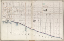
Joseph H. Bonsall & Samuel L. Smedley. “Section 13.” [Port Richmond: East Butler south to East Somerset and Belgrade Street east to Delaware River]
Philadelphia: S. L. Smedley, 1860. From A Complete Atlas of the City of Philadelphia... 20 ¾ x 32 (piano key border). Lithograph with original outline hand color. Archival tape repairs on verso. Any map from this atlas is extremely scarce.
An extremely scarce map from the first atlas of the city of Philadelphia following the consolidation of the city in 1854. Samuel L. Smedley was born on 29 December 1832, at Edgemont, Delaware County, and was educated at Westtown Academy and at a school in Germantown. In 1853 he moved to Philadelphia to work for another Edgmont native, Joseph Fox, a Philadelphia surveyor, to learn drafting and civil engineering. Development increased after Philadelphia County's various townships and other municipalities united in 1854 to create the modern city. In 1856, Smedley was appointed by the commissioners of Blockley Township to plot streets there. In 1858, he became a member of the Board of City Surveyors and, in 1862, he published the first complete street atlas of Philadelphia. City Councils named him Chief Engineer and Surveyor of Philadelphia in 1872, a position he held until his retirement in 1893. During his tenure, he oversaw the construction of the Schuylkill bridges at Penrose Ferry, Market Street, Walnut Street, Spring Garden Street and Girard Avenue, and superintended much of the development of Fairmount Park's walks and drives. He supervised construction of the 116-foot aqueduct arch that crosses Cresheim Creek where it meets the Wissahickon Creek. On its completion in 1892 it was considered an engineering marvel and was said to be the second largest stone arch in America.
 %20%0A%20%0Ahttps://philaprintshop.com/products/bonsall-smedley-section-13-port-richmond-east-butler-south-to-east-somerset-and-belgrade-street-east-to-delaware-river %20%0A%20%0ABonsall%20%26%20Smedley.%20%20%E2%80%9CSection%2013.%E2%80%9D%20%20[Port%20Richmond:%20East%20Butler%20south%20to%20East%20Somerset%20and%20Belgrade%20Street%20east%20to%20Delaware%20River] %20%0A%20%0A//philaprintshop.com/cdn/shop/products/smedley13c_1024x1024.jpg?v=1662755624 %20%0A%20%0AAntique Prints, Maps, Drawings, Paintings and Rare Books! %20%0A%20%0AThe Philadelphia Print Shop %20%0A106 E. Lancaster Avenue, Lower Level %20%0AWayne, PA 19087 %20%0A%20%0APhilaPrintShop.com %20%0A@PhiladelphiaPrintShop %20%0A 610 (808) 6165)