


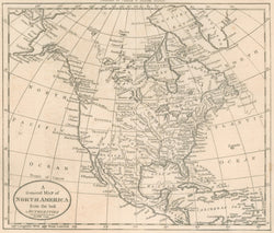
"A General Map of North America from the best Authorities." From Jedidiah Morse's The American Universal Geography.
Boston: Thomas & Andrews, June 1796. 7 1/2 x 8 3/4. Engraving by A. Doolittle. Wheat & Brun: 55. Very good condition.
A fine late eighteenth century map of North America. This map was from Jedidiah Morse's Geography, one of the first American publications of its kind. Morse, the father of Samuel F.B. Morse, established himself in the 1780s as one of the leading producers of American maps. Doolittle, the engraver, is one of the great names in American engraving, especially during the Revolution. The map is of interest because of its early detail: the Northwest Territory is noted east of the Mississippi River, the "Acansis R" appears for the Arkansas River, and "Iowa Town" is an Indian town in present-day Iowa. The first Morse map of North America.
 %20%0A%20%0Ahttps://philaprintshop.com/products/morse-jedidiah-a-general-map-of-north-america-from-the-best-authorities %20%0A%20%0AMorse,%20Jedidiah%20%22A%20General%20Map%20of%20North%20America%20from%20the%20best%20Authorities.%22 %20%0A%20%0A//philaprintshop.com/cdn/shop/products/morsena1796c_1024x1024.jpg?v=1651593075 %20%0A%20%0AAntique Prints, Maps, Drawings, Paintings and Rare Books! %20%0A%20%0AThe Philadelphia Print Shop %20%0A106 E. Lancaster Avenue, Lower Level %20%0AWayne, PA 19087 %20%0A%20%0APhilaPrintShop.com %20%0A@PhiladelphiaPrintShop %20%0A 610 (808) 6165)