


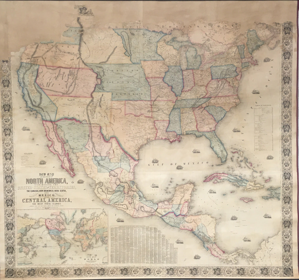
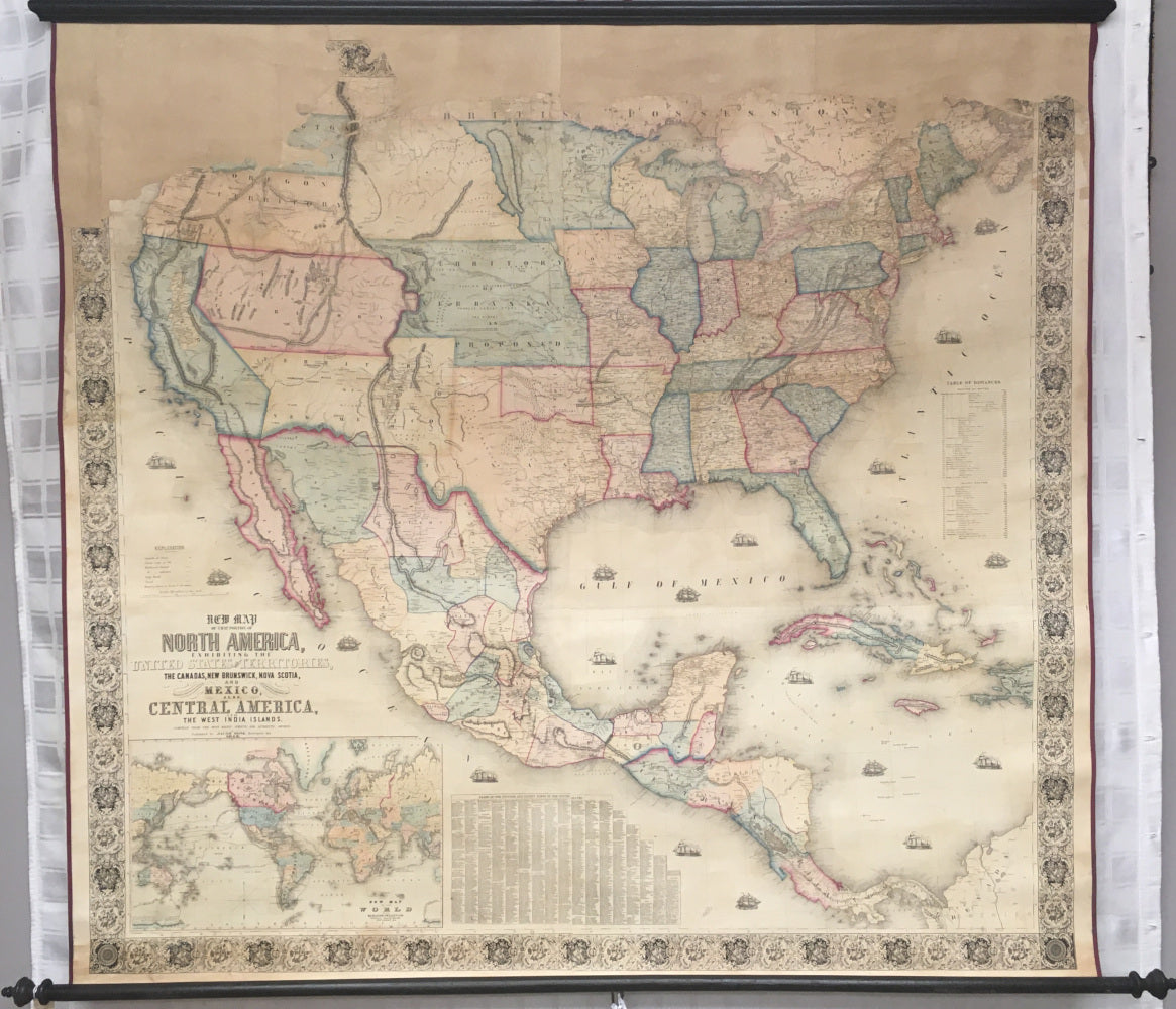
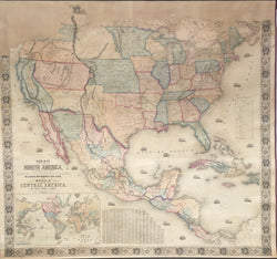
Jacob Monk. "A New Map of that portion of North America exhibiting the United States and Territories, the Canadas, New Brunswick, Nova Scotia, and Mexico, also, Central America, the West India Islands. Compiled from the most recent surveys & authentic sources."
Baltimore: Jacob Monk, 1853. Separately issued wall map. 55 x 59. Lithograph by A. Hoen & Co. 57 x 61. Full original hand color. Most of the top of the printed area is missing from four to eight inches across the top; Washington Territory is the only part that is missing from the U.S. portion. Map professionally conserved and lined. Overall, very good appearance. Ref.: Wheat, Transmississippi West, III: 163-4 and 328-9.
An unusual 1853 version of Monk's impressive map of North America, an early edition in a series of wall maps published between 1851 and 1863. The map focuses on transportation routes crisscrossing the country, including railroads built and proposed, and tables are included at the right listing distances along water and inland routes between cities. Also of focus are the trails and exploration routes in the West. For instance, the Oregon Trail is shown with stopping places marked and miles between noted. Monk also indicates the water routes to California, with a number of ship vignettes gracing the seas. An inset map of the world, in the lower left, shows explorer routes around the globe. In the eastern part of the United States much information is given, providing a terrific contemporary image of the developed part of the country at mid-century.
It is for the western part of the country that this map is of most interest. The map was issued just after the "Compromise of 1850," which set the political situation in those lands won in the recent war with Mexico. California was admitted as a state, and the rest of the new lands were divided into New Mexico and Utah Territories, both shown here. This map was issued in the heyday of the California gold rush, so Monk features a rather large depiction of the "Gold Region" in California. To the immediate west of the Mississippi River, the northern most region is shown as Minnesota Territory, below which are the states of Iowa, Missouri, Arkansas and Louisiana, the west of which is the state of Texas. The lands acquired by the United States in 1853, with the Gadsden Purchase, are here shown as part of Mexico. Monk was very concerned to keep his maps up-to-date and in 1853, the idea of establishing a new Nebraska Territory, to be created out of the unorganized Indian Territories, was being floated. As some point in 1853, Monk added the indication of "Nebraska Territory as Proposed," which was not shown in the early 1853 version. (Cf. Rumsey #602.) Monk shows this territory as including all of later Kansas Territory and the southern part of what was created as Nebraska Territory in the 1854 Kansas-Nebraska Act. Another salient feature of Monk's map is his careful location of Indian tribes, many indicated with separate coloring.
 %20%0A%20%0Ahttps://philaprintshop.com/products/monk-a-new-map-of-that-portion-of-north-america-exhibiting-the-united-states-and-territories-the-canadas-new-brunswick-nova-scotia-and-mexico-also-central-america-the-west-india-islands-compiled-from-the-most-recent-surveys-authentic-sources %20%0A%20%0AMonk,%20Jacob%20%22A%20New%20Map%20of%20that%20portion%20of%20North%20America%20exhibiting%20the%20United%20States%20and%20Territories,%20the%20Canadas,%20New%20Brunswick,%20Nova%20Scotia,%20and%20Mexico,...%22 %20%0A%20%0A//philaprintshop.com/cdn/shop/products/monkus1853c_1024x1024.jpg?v=1649184276 %20%0A%20%0AAntique Prints, Maps, Drawings, Paintings and Rare Books! %20%0A%20%0AThe Philadelphia Print Shop %20%0A106 E. Lancaster Avenue, Lower Level %20%0AWayne, PA 19087 %20%0A%20%0APhilaPrintShop.com %20%0A@PhiladelphiaPrintShop %20%0A 610 (808) 6165)