

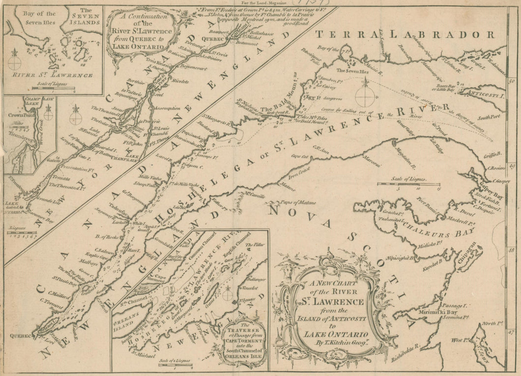


Thomas Kitchin (1818-84). “A New Chart of the River St. Lawrence from the Island of Anticosti to Lake Ontario By T. Kitchin Geogr.” [Canada] From London Magazine.
London: September 1759. 7 1/8 x 10. Engraving. Left hand margin trimmed to neat line. With folds as issued. Else, very good condition.
The British journal, London Magazine, was the source of some of the most important and elegant maps and views of colonial America. During the eighteenth century the English gentleman was kept well informed through fine visual images, as well as articles, about the latest activities in the developing colonies of North America. The most up-to-date, authoritative sources were used, making for the dissemination of, and subsequent preservation of, some of the finest early historical documents about America. This was especially true during the French & Indian War. The readers in England would have been hungry for news, textual and visual, of this important conflict across the Atlantic, and publications such as London Magazine would have provided an eagerly awaited source for this.
This detailed map of the St. Lawrence River is an excellent example of fine cartographic work published by the journal. The author is Thomas Kitchin, a prominent English cartographer of the period, and Hydrographer to the King. The area depicted was of crucial importance for the war in 1758-59. In the summer of 1758, the British finally captured the city of Louisbourg, Nova Scotia, establishing control of the Bay of St. Lawrence, the entry to the river. The river was the main artery to the interior of northern America, so this marked the death knell of New France. This map includes three insets, as well as the main map, one of which shows the area at the foot of Lake Champlain, with Crown Pont and Ticonderoga, the scene of much military activity in 1758 and 1759.
 %20%0A%20%0Ahttps://philaprintshop.com/products/kitchin-thomas-a-new-chart-of-the-river-st-lawrence-from-the-island-of-anticosti-to-lake-ontario %20%0A%20%0AKitchin,%20Thomas%20%E2%80%9CA%20New%20Chart%20of%20the%20River%20St.%20Lawrence%20from%20the%20Island%20of%20Anticosti%20to%20Lake%20Ontario%22 %20%0A%20%0A//philaprintshop.com/cdn/shop/files/kitchinstlawrencethmb_1024x1024.jpg?v=1698940486 %20%0A%20%0AAntique Prints, Maps, Drawings, Paintings and Rare Books! %20%0A%20%0AThe Philadelphia Print Shop %20%0A106 E. Lancaster Avenue, Lower Level %20%0AWayne, PA 19087 %20%0A%20%0APhilaPrintShop.com %20%0A@PhiladelphiaPrintShop %20%0A 610 (808) 6165)