![Ptolemy, Claudius. “Tabula Asia IX.” [Pakistan]](http://philaprintshop.com/cdn/shop/products/ptolemy-pakistanc_{width}x.jpg?v=1678907320)
![Ptolemy, Claudius. “Tabula Asia IX.” [Pakistan]](http://philaprintshop.com/cdn/shop/products/ptolemy-pakistan_{width}x.jpg?v=1678907326)
![Ptolemy, Claudius. “Tabula Asia IX.” [Pakistan]](http://philaprintshop.com/cdn/shop/products/ptolemy-pakistanc_530x@2x.jpg?v=1678907320)
![Load image into Gallery viewer, Ptolemy, Claudius. “Tabula Asia IX.” [Pakistan]](http://philaprintshop.com/cdn/shop/products/ptolemy-pakistanc_1024x1024@2x.jpg?v=1678907320)
![Load image into Gallery viewer, Ptolemy, Claudius. “Tabula Asia IX.” [Pakistan]](http://philaprintshop.com/cdn/shop/products/ptolemy-pakistan_1024x1024@2x.jpg?v=1678907326)
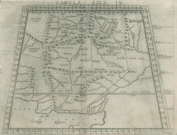
Claudius Ptolemy (c.100-c.170). “Tabula Asia IX.” [Pakistan]. From La Geografia di Claudio Tolomeo.
Venice: Giordano Ziletti, [1561]-1574. 7 3/8 x 10 1/4 (plate mark). Engraving. Full margins. Very good condition.
A map from Giordano Ruscelli’s La geografia di Claudio Tolomeo. The Geographia, is perhaps the most influential work on geography ever published. It introduced the notions of longitude and latitude, of scientific plotting, of a northerly orientation, and most importantly, it preserved the ancient understanding of the world. When Ptolemy put together his Geographia ca. A.D. 150, regions around the Mediterranean were quite well known, especially its oft-sailed coasts, and so those depictions are quite accurate. Settlements are shown, mostly on the coast, and rivers and some indication of interior mountains. Of particular note is the fact that the maps based on millenium and a half old information was issued in the same atlas as the very current Ruscelli maps. The publication of both the old-Ptolemaic and the “modern” rendition of each part of the world was a common practice in the sixteenth century, and is a wonderful reflection of the culture and world view of that period.
 %20%0A%20%0Ahttps://philaprintshop.com/products/ptolemy-claudius-tabula-asia-ix-pakistan %20%0A%20%0APtolemy,%20Claudius.%20%20%E2%80%9CTabula%20Asia%20IX.%E2%80%9D%20%20[Pakistan] %20%0A%20%0A//philaprintshop.com/cdn/shop/products/ptolemy-pakistanc_1024x1024.jpg?v=1678907320 %20%0A%20%0AAntique Prints, Maps, Drawings, Paintings and Rare Books! %20%0A%20%0AThe Philadelphia Print Shop %20%0A106 E. Lancaster Avenue, Lower Level %20%0AWayne, PA 19087 %20%0A%20%0APhilaPrintShop.com %20%0A@PhiladelphiaPrintShop %20%0A 610 (808) 6165)